Mountain Bike Trail Guide: Smith Rock and Gray Butte trails
Published 12:00 am Thursday, April 26, 2018
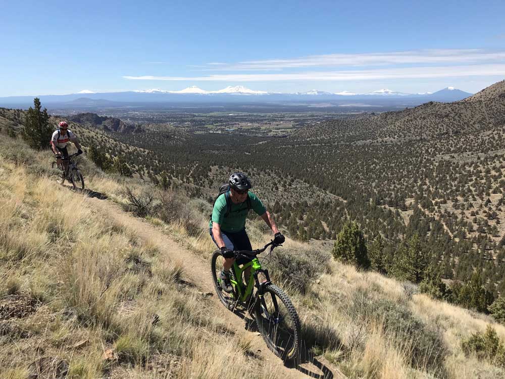
- Two mountain bikers ride the Gray Butte Trail near Smith Rock State Park.
TERREBONNE — As Smith Rock State Park becomes increasingly busy during the spring, rock climbers and hikers can feel the squeeze in the more popular areas of the park.
One way to avoid some of the crowds but still enjoy the area’s dramatic scenery is to bring a bike.
Mountain biking is not the activity for which Smith Rock is known, but the area is home to some pretty thrilling trails that can make for an ideal all-day springtime outing. And a bike can get folks more quickly to some of the more remote and less used areas surrounding the park, such as Burma Road, the Gray Butte Trail, and the Summit Trail.
These trails, combined with the Wolf Tree Trail and the River Trail, provide a dandy 13-mile loop/out-and-back ride that includes all the things that most mountain bikers love: tacky singletrack, punishing climbs and amazing vistas. Riding in the area offers a chance for mountain bikers to whip themselves into shape in the early season and enjoy trails that are vastly different from the forested singletrack closer to Bend.
Last Friday seemed like the first springlike day of the season in Central Oregon. After weeks of cold, wet and snowy conditions, the sun was shining bright and temperatures would top out in the 60s.
Smith Rock was bustling when my riding partner Mark Johnson and I arrived at the parking area after making the 40-minute drive from Bend. I noticed license plates from Texas, South Carolina, British Columbia. When we stepped out of the car after parking, some folks nearby were speaking Russian.
Widely recognized as the birthplace of sport climbing in the United States, Smith Rock is a mecca for rock climbers around the world.
Hoping to not add to the issue of overcrowding at certain areas of the park, we quickly linked up to the lightly used Wolf Tree Trail after crossing the footbridge in the middle of the park. After just a couple of minutes on the trail, we left the crowds behind and followed the Crooked River to an area of the park with few rock climbing routes — and thus, few people.
Connecting onto Burma Road required tackling a steep section of loose dirt — too steep to ride — where we had to walk our bikes. Once atop that section we turned onto Burma Road: a dirt doubletrack that rises sharply along a barren hillside just outside the park. Drivers on nearby U.S. Highway 97 can see the road carved into the hill.
While ascending Burma is an arduous endeavor on a mountain bike, once at the top, riders have access to some unique trails, including the Gray Butte Trail. The memorable hillside singletrack that leads to Gray Butte offers sprawling views of the Crooked River National Grassland and the Cascade Range and is one of my favorite sections of trail in all of Central Oregon.
Burma ended up as a walk/ride for us. Some of the sections were just too steep and demanding to continue pedaling. But when we finally made it to the top, we took in the inspiring view from the roof of Smith Rock. From that spot, we were higher than most all of the popular climbing walls, and the snow-capped Cascades to the west towered over the rock formations.
From the top of Burma Road, bikers can connect to the Gray Butte Trail leading toward the butte. Several options exist, including completing the Cole Loop to the east or the Burma Loop to the north. Both rides skirt the summit of Gray Butte. Some mountain bikers also shuttle to start from near the top of Gray Butte and ride (mostly downhill) all the way back to Smith Rock.
Our plan was to ride the Gray Butte Trail until we tired of ascending, then turn around and ride it back to the Summit Trail, then connect to the River Trail, which would lead us back through the park and complete the loop.
The Gray Butte Trail cuts along the hillside and is fast, flowing and fun. Keeping both eyes on the trail is a must, because it runs along a precipitous drop-off to the northwest, and veering off the narrow singletrack could get a rider hurt. If bikers want to take in the view — which is hard to ignore — it is best to stop first.
Where the hillside section ends, bikers can connect to the Cole Loop Trail or continue along the Gray Butte Trail.
We continued on the Gray Butte Trail, and as the trail became increasingly uphill toward the butte, we decided to turn around. Riding the trail back toward the park is even more exhilarating, as that direction is more downhill and puts riders face to face with glowing-white Cascade peaks.
Back at the junction of the Gray Butte Trail and Burma Road, we turned onto the Summit Trail, a path of switchbacks that connects to the River Trail on the west side of the park.
The switchbacks are so sharp that we were forced to clip out of our pedals on most all of them, but we eventually made it down the hillside to reach the River Trail on the park’s west side.
The trail led us back alongside the meandering Crooked River, and Monkey Face, the renowned 300-foot rock spire, loomed ahead. As we got closer, we noticed several rock climbers clinging to the walls of the impressive rock formation.
As we rode back into the main area of Smith Rock, an osprey and a turkey vulture circled alongside the vertical cliffs, eyeing prey far below.
The trail grew more crowded with hikers, and we rode slowly through the heart of the park. Mountain bikers should ride with caution and yield to hikers in that section.
After climbing back up to the parking area, our legs were sore and our lungs busted after the nearly four-hour, 13-mile ride, which included 2,800 feet of elevation gain.
But despite the challenge, riding a mountain bike just might be the best way to tour the incredible area of Smith Rock and Gray Butte.
— Reporter: 541-383-0318,
mmorical@bendbulletin.com

Best of the Best of Bend 2025

-
-
-