Central Oregon snowpack not shaping up well
Published 12:00 am Friday, February 2, 2018
- Central Oregon snowpack not shaping up well
Following a couple of early storms and the formation of another La Niña weather pattern, many Central Oregonians braced for another snowier-than-usual winter.
But not only has this winter failed to live up to last year’s record-setting snowfall, there has been virtually no snow across large swaths of Central Oregon, which could lead to a shortage of irrigation water for the region.
“This is definitely where we don’t want to be on February 1st,” said Kyle Gorman, south central region manager for the Oregon Water Resources Department.
Since the start of December, the National Weather Service office in Pendleton has recorded just traces of snow at its Bend site, nearly a foot less than normal over that period.
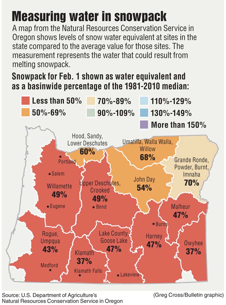
Gabriella Coughlin, soil scientist for the Redmond office of the Natural Resources Conservation Service, a wing of the U.S. Department of Agriculture that handles snow sampling, said high-elevation areas of Deschutes County were more of a mixed bag. Coughlin said a snow sample taken at the highest-elevation portion of the survey on Thursday showed snow-water equivalent — a measurement used by researchers to determine how much water is present in snow — that is slightly above the 30-year average for the beginning of February, though lower-elevation sites were below average.
“Central Oregon is fair to middling right now,” Coughlin said.
The automated regionwide numbers are even worse. As of Thursday evening, automated snow monitoring sites across the lower Deschutes Basin averaged 49 percent of the median snow-water equivalent, meaning that the snowpack is less than half of what a normal winter would bring.
And Central Oregon is not alone. With the exception of the northeastern corner of the state, the snowpacks feeding all of Oregon’s basins are at least 40 percent below average. Statewide, the snowpack is barely half of average, and it took a wet end of January to even get to that level, according to Scott Oviatt, snow survey supervisor for the resource conservation office in Portland.
“The message is that we need a lot more snowfall to get back to normal,” Oviatt said.
In October, the weather service’s Climate Prediction Center noted that a La Niña weather pattern is likely to occur this winter in the Northern Hemisphere. In Oregon, that tends to mean cool temperatures and more precipitation than normal.
Marilyn Lohmann, hydrologist for the weather service’s Pendleton office, confirmed that a weak La Niña weather pattern is in place, but the weather that normally accompanies it in Oregon has not followed suit. December was more than a degree colder than usual on average, but the chilly weather was accompanied by very little precipitation, according to data from the weather service.
Lohmann said the large-scale weather pattern shifted in mid-December, thanks to a persistent high pressure system caused by warm water off the coast of Southern California. She said Central Oregon is near the northern edge of the weather pattern.
“That’s pushed the storm track a little north,” Lohmann said.
She added that winter storms off the Pacific Ocean typically travel from Northeast Oregon to the southeast, but the high pressure has pushed most of them into British Columbia and Washington. As a result, most basins in northern Washington and northern Idaho have at least as much snow as usual, but Lohmann said areas to the south, including Arizona and California, have struggled.
Oviatt said Oregon overall has not been noticeably drier than usual, with statewide precipitation coming in at only 8 percent less than the 30-year average. It just hasn’t translated to snow in low-elevation areas.
“When precipitation did fall, it mainly fell as rain,” Oviatt said.
Thanks to last year’s winter, Gorman said most of Central Oregon’s reservoirs were in good shape heading into the winter. For the most part, they remain that way, with only Prineville Reservoir having slipped below average among the region’s large reservoirs.
“The carryover from last year has left us in excellent position,” he said.
Gorman said he was confident that many of the reservoirs in the region would fill during the spring, but added that, if conditions don’t improve, rivers and streams could run low and farmers will draw heavily from the reservoirs, particularly Wickiup Reservoir, over the summer to get enough water. Once the reservoirs get drawn down, it can take some time for them to return to healthy levels.
Gorman identified February as a particularly important month for the Central Oregon’s snowpack, as it marks the end of a three-month window when a good portion of the region’s snow typically falls.
Lohmann added that weather in Central Oregon is expected to be near normal, as far as both precipitation and temperature goes, which should lead to a bit more snow going forward. Coughlin said she was optimistic that recent storms could indicate a more normal La Niña cycle for the rest of the winter.
“The fact that we’re seeing (snow) hang out a little longer up top gives us optimism,” Coughlin said.
— Reporter: 541-617-7818, shamway@bendbulletin.com


Best of the Best of Bend 2025

-
eEdition

-

-
Go! eEdition