Tackling Hayrick Butte
Published 4:00 am Thursday, March 10, 2011
- Tackling Hayrick Butte
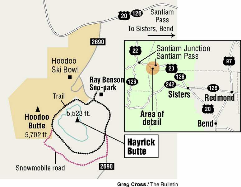
Hoodoo Mountain Resort bills itself as a family-friendly ski area. Hayrick Butte, right next door, is decidedly antisocial.
Dark and forbidding, Hayrick looms over its neighbor like a citadel of stone covered in snow and pines. Its near-vertical walls give it the look of an impenetrable fortress, a castle to lay siege upon instead of attempting a direct attack.
Trending
Truth be told, I still plan to climb to the top of the butte. There’s a geocache there, so it’s definitely doable. But on Sunday, I wasn’t nearly confident enough that the snow on its steep slopes would hold. So I decided on a four-mile circumnavigation of Hayrick Butte, hoping for some close-up reconnaissance that might reveal a weakness in its defenses.
I parked at the Ray Benson Sno-park, which shares access from U.S. Highway 20 with the ski resort. (Access to sno-parks in winter should never be assumed, as I learned Friday. My initial destination, Corbett Sno-park, is closed this winter because of vandalism, a history of low snow levels and budget shortfalls.)
Donning snowshoes, I set out alongside a snowmobile route, known as the Sand Mountain Loop. A mere 200 feet from the sno-park, I had to decide whether to circle Hayrick clockwise or counterclockwise.
It’s probably a little easier to turn left on Sand Mountain Loop and go clockwise, so you can stick to the groomed snowmobile route clear to the other side of the butte. Turning right and going counterclockwise runs you into ungroomed backcountry conditions sooner. Eventually you’ll hit the snowmobile road on the other side, but unless you’re glued to your GPS, it’s unlikely you’ll hit the road right at its end point.
I had no great desire to spend my morning hiking on a road, so I opted to go counterclockwise, traversing above the tubing park and then skirting the boundary of the ski resort. In this direction the snowmobile road peters out within a half mile and I was soon making my way through a sparse forest on untrodden snow.
It’s really impossible to get lost circling Hayrick. The butte is visible at all times through the forest. All you need to do is pin your shoulder to the butte and you’ll end up back where you started.
Trending
Hayrick is considered one of the most perfect examples of a tuya, a type of volcano that forms when lava erupts underneath a glacier or ice sheet. The lava melts through to the surface and pools, creating a plateau with near-vertical walls. Hayrick has a flat top about a half mile across with 700-foot-high walls.
The snow was less than ideal for a snowshoe trip. There was a thin crust of hard snow over unconsolidated powder. Even with snowshoes on, I punched through the crust with nearly every step.
I headed for the gap between Hayrick and Hoodoo buttes, and once I had cleared the saddle, the slope began to drop away beneath my snowshoes. The walls on the southwestern side of Hayrick are less extreme, and as I circled around the backside, I could see an obvious route to the top of the butte.
But the top would have to wait for another day. I could also see areas where the snow on this side had slid, disturbingly right where snowmobilers had looped up and down the slope.
Around the southwestern side of the butte, I was definitely within the semicircle formed by the snowmobile roads. But sticking closer to the butte, I could circle through the trees instead.
I continued to pick my way through the forest, carefully avoiding the tree wells, lest a recovery team should have to pull my frozen body out by my snowshoes several days later. The crunch of the snow drowned out the whine of mosquitoes buzzing like 800cc go-karts on the flats below.
I tried to find the path of least resistance, avoiding climbing up any slopes if I could avoid it. Eventually that strategy pushed me down the Sand Mountain Loop again, probably about a half mile from the sno-park.
Soon signs of civilization began to intrude: a couple cross-country skiing, a half-buried road sign, and a trio of snowmobilers. As they passed, I breathed in my recommended daily allowance of heavy metals and knew why I had avoided the road most of the way.
If you go
What: Hayrick Butte
Getting there: From Sisters, take U.S. Highway 20 west to Santiam Pass. Take the turnoff for Hoodoo Ski Area on the left side of the highway and follow the signs for the Ray Benson Sno-park.
Difficulty: Strenuous
Cost: Sno-park permit required through April 30
Contact: Willamette National Forest, 541-225-6300
Switched at birth?
According to the book “Oregon Geographic Names,” Medford cartographer Stuart Allen suggested in 1999 that the names of Hayrick and Hoodoo buttes may have been switched through an early mapmaker’s error. The term “hoodoo” is commonly used in the Western U.S. to refer to rock piles or pinnacles of interesting shapes, and Hayrick Butte does have many such formations, such as in the photo. Hoodoo Butte, on the other hand, closely resembles a hayrick, another term for haystack.
Marketplace


Enter the $5,000 Sweepstakes

-
eEdition

-

-