With many trails under snow, try the hike to Carl Lake
Published 4:05 pm Monday, August 7, 2017
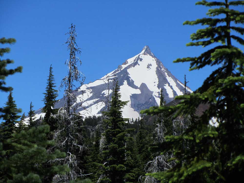
- Mount Jefferson is seen from near Cabot Lake.
With snow still blocking many trails at about 6,000 feet, hikers are facing a two- to three-week delay to the high-elevation backcountry hiking season this summer in the Central Oregon Cascades.
About 75 percent of the ultrapopular Green Lakes Basin and the Three Sisters Wilderness is still under snow, according to Mike Bishop of the Deschutes National Forest’s Sisters Ranger District.
“There’s a lot of folks getting turned around out there because the trails are still covered in snow,” Bishop said Wednesday. “It’s pretty easy for people to kind of lose their way. It was the best winter (for snow) we’ve had in 20 years, and not a lot of people are used to it, I guess. All of our trailheads are open now, and most of them you can go about 3 or 4 miles until you hit the snow line.”
Looking for a scenic wilderness hike but not wanting to encounter snow before accessing dramatic alpine terrain and views, I ventured northwest of Bend to the Mount Jefferson Wilderness earlier this week. The Cabot Lake Trail would take me 4½ miles to Carl Lake, at about 5,600 feet in elevation, just east of the Cascade crest.
Accessing the Cabot Lake Trailhead requires a drive of about 14 miles on paved and gravel Forest Service roads north from U.S. Highway 20 near Suttle Lake.
After a drive of about an hour and 20 minutes from Bend, I arrived at the trailhead to find only two other cars parked there. (The more popular Canyon Creek Meadows trailhead at Jack Lake is located south of there, but the Cabot Lake trail would appear to offer more solitude.)
“I would say that lake does not get as used as most lakes,” Bishop said of Carl Lake.
The dusty trail started out through thick, green manzanita and snowbrush, which have flourished in the area since the B&B Complex Fire burned more than 90,000 acres of the forest in 2003. The pointed summit of Mount Jefferson rose above a ridge to the north, and after a mile or so, the manzanita gave way to Douglas fir and mountain hemlock trees.
After passing the small Cabot Lake, the trail became rockier and led me up a series of switchbacks to a few more small alpine lakes. The terrain was not terribly challenging, and a few of the steeper, rocky sections were broken up by flat, smooth sections of dirt.
When I finally arrived at Carl Lake about two hours into the trek, I was mesmerized — and somewhat surprised — by the sheer beauty of the deep blue lake that was rimmed by rocky, snow-covered cliffs. I really had not known what to expect.
The trail continues around the south and west sides of the lake, but I soon encountered deep swaths of snow that blocked the trail. Some of the snow piles appeared fairly easy to climb over, but I knew they would grow increasingly bigger and I would eventually lose the trail entirely. I decided to turn around after the second significant snow pile, even though my original plan was to continue on to a viewpoint featuring Mount Jefferson located between Carl Lake and nearby Junction Lake.
“We’re recommending people make good decisions,” Bishop said. “If it’s getting to where the snow is increasing and you’re having a difficult time finding your way, I would recommend going out the way you came in just to avoid any confusion and a possible search and rescue.”
The snow line currently ranges from about 6,000 to 6,500 feet in the Central Oregon Cascades, according to Bishop. While high temperatures well into the 80s this week will help hasten the accessibility of trails, hikers might have to wait a few more weeks yet to reach their favorite areas of the Cascades.
“Right now, our trails are getting washed out,” Bishop explained. “A lot of muddy conditions and water runoff. … Post-holing is occurring. Even with snowshoes, people are caving in a couple feet or so. Our backcountry season usually starts in mid-July, which is right now. Since April or May, we figured we would have a two- to three-week late start with a lot of our openings, when it comes to our higher-elevation roads and areas.
“Stuff will start to change a lot faster. Conditions will get better. August should be pretty busy out there.”
For those hikers and backpackers looking to avoid crowds, Carl Lake certainly seems like a prime option. During my trek, I saw a few hikers at the trailhead but only two along the trail.
After exploring the relatively snow-free east end of the lake — including a small waterfall brimming with snowmelt — I made my way back the way I had come. The 11-mile hike required nearly four hours, and it was well worth the effort.
As Central Oregon wilderness trails become packed next month after more of the snow melts, hikers might want to consider venturing into the less-crowded Mount Jefferson Wilderness.
— Reporter: 541-383-0318,
mmorical@bendbulletin.com
Carl Lake hike
Directions: From Sisters, follow U.S. Highway 20 northwest for about 12 miles, then turn right on Forest Road 12, following it north to Forest Road 1230 (near Jack Creek). Stay on 1230, and Cabot Lake Trailhead is at the end of 1230.
Free permits: Wilderness permits are required for both day-use and overnight stays. The free permits are self-issued at the trailhead. Mountain biking and motorized use are prohibited.


Best of the Best of Bend 2025

-
-
-