Three sides of Mount St. Helens
Published 6:30 am Monday, September 11, 2017
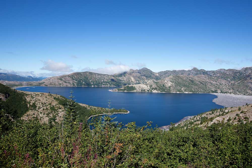
- Spirit Lake, once a gem of the Cascades, is twice the size it was before the 1980 eruption. The great landslide raised the lake level 200 feet and inundated the historic Spirit Lake Lodge and its resident owner, 83-year-old Harry Truman. (Barb Gonzalez/For The Bulletin)
RANDLE, Wash. —
The young motorcyclist stood atop the Windy Ridge lookout at Mount St. Helens National Volcanic Monument, 438 hard-won steps above the parking area where he had left his bike. He gazed upon a desolate landscape, devoid of trees and tickled only by a new ground cover clinging to an expanse of ash and pumice.
“What happened here?” he innocently asked an older couple standing beside him on the bluff. “Was there a forest fire?”
Well, no. Something a bit more devastating occurred 37 years ago. The mountain blew up.
And it’s only now showing real signs of recovery.
The man had come to see the volcano, he said. It had erupted before he was born. Perhaps he had envisioned a fiery explosion that sent fountains of molten lava shooting into Pacific Northwest skies, rolling downhill as a viscous river that slowly hardened as it flowed.
That sort of eruption is the kind that happens in places like Hawaii, where Kilauea Crater’s lava flow inches the Big Island further into the Pacific Ocean.
It’s not what happened here.
May 18, 1980
The eruption of Mount St. Helens was different, as the couple patiently explained to the young man.
Almost from the time white men first settled in the region, the mountain had been a placid presence in the Washington Cascades. Standing at 9,677 feet, higher than Oregon’s Mount Bachelor and easily seen from Portland on clear days, its symmetrical cone earned it comparisons with Japan’s Mount Fuji. For decades, the serene Spirit Lake Lodge and nearby campgrounds were popular weekend and vacation destinations for Northwesterners.
No geothermal activity had been recorded since the 1850s. But in early 1980, the mountain began to show signs of awakening. Steam and ash wafted from a vent near the summit. A series of small earthquakes signaled magma movement deep underground, and seismologists warned of an impending eruption.
It began just after 8:30 a.m. on Sunday, May 18, when a magnitude 5.1 earthquake triggered a landslide on the north side of the mountain. As its peak crumbled, St. Helens lost more than 1,300 feet of elevation. A pyroclastic flow of earth, rocks, ash, steam and toxic gases rumbled downhill in what is now considered the greatest debris avalanche in recorded history. The slide consumed Spirit Lake, raising its water level more than 200 feet and swallowing the popular lodge.
Meanwhile, a lateral blast took down anything on the north side of the mountain that the landslide might have missed. More than 230 square miles were denuded of trees, other foliage and any man-made structures. Meanwhile, volcanic mudflows, or lahars, flowed 50 miles down the Toutle and Cowlitz rivers to the Columbia River near Longview.
Day becomes night
Intense pressure released at last, the mountain — or what remained of it — blew its top, releasing more than 1.5 million metric tons of sulfur dioxide into the atmosphere. A mushroom cloud of ash spewed for more than nine hours, reaching about 80,000 feet (more than 15 miles) above the mountain. Prevailing winds urged the cloud eastward, blanketing Yakima in 5 inches of ash by mid-morning; Spokane was immersed in darkness by noon, and Denver reported ash fall the following morning.
The eruption killed 57 people, including Harry Truman, 83, who refused to evacuate his beloved Spirit Lake Lodge, and David Johnston, 30, an on-site volcanologist who first reported the eruption to the U.S. Geological Survey: His final radio report was, “Vancouver! Vancouver! This is it!” The Johnston Ridge Observatory is named in his honor.
All but four of the fatalities occurred outside of a safety perimeter that had been established. About 7,000 big-game animals — elk, deer and bear — and about 12 million fish were estimated to have died. More than 200 homes, 185 miles of highway and 15 miles of railway track were also destroyed.
The mountain has been periodically active since the 1980 eruption, the single most devastating in U.S. history. Since then, St. Helens has occasionally erupted with small explosions and clouds of ash. It continues to vent steam.
Western approach
There are three ways to approach Mount St. Helens by road. By far the most popular is from the west, off Interstate 5 at Castle Rock.
With the lapse of time since the big eruption, Castle Rock, a town of 2,000 people located 10 miles north of Kelso, no longer teases travelers with a promise of gift shops that sell vials of volcanic ash, nor with a large-format film that recreates the eruption. In fact, other than a handful of gas stations, fast-food restaurant and motels, there’s no reason to stop here.
Five miles east, however, at Seaquest State Park, is the Washington State Parks’ Mount St. Helens Visitor Center. Had this been the first stop for the young Windy Ridge visitor, he may not have been puzzled by the devastation he perceived. Exhibits here recount the history of the mountain, which the native Klickitat Indians knew as “Loowit” (“smoking peak”), and which early white pioneers saw in eruption phase between 1842 and 1857. A movie and most of the display detail the events of May 1980.
Washington State Highway 504 extends 52 miles from Castle Rock to the Johnston Ridge Observatory. The excellent road — rebuilt almost entirely since 1982, when Mount St. Helens National Volcanic Monument was established under the aegis of Gifford Pinchot National Forest — follows the North Fork of the Toutle River, which can be seen coursing through the mud flats left by the eruption.
Twenty miles from Castle Rock, past the village of Toutle in the unincorporated hamlet of Kid Valley, stands a 28-foot sasquatch sculpted from concrete and Mount St. Helens ash. It stands beside a red A-frame, half-buried in volcanic mud, and the North Fork Survivors Gift Shop. The roadside stop is only about a mile east of the Fire Mountain Grill, the most reputable restaurant on this side of St. Helens.
Recovering life
Highway 504 passes through extensive forests of noble fir, Douglas fir, lodgepole pine and black cottonwood planted by the Weyerhaeuser Company between 1981 and 1987. Weyerhaeuser was the largest private landholder affected by the eruption, with nearly 68,000 acres of forest lands destroyed. At its Charles W. Bingham Forest Learning Center, open through September, exhibits describe how the wood-products corporation hand-planted 18.4 million seedlings to help recover the forest.
Lovely Coldwater Lake, created when debris from the eruption blocked a Toutle River tributary, has a picnic area and a boat launch for non-motorized vessels. Four miles long and a half-mile wide, it is popular both for kayaking and fishing and as a trailhead for a 10-mile hike through the nearby Mount Margaret Backcountry.
Overlooking the lake, the Mount St. Helens Science and Learning Center at Coldwater is a youth education center in summer, a visitor facility when the Johnston Ridge Observatory is closed (November to mid-May).
The observatory itself is a low concrete structure that sits at about 4,300 feet elevation. From here, wisps of steam can clearly be seen rising from the crater, five miles away and more than a mile across. Several trails lead to additional viewpoints. Exhibits include a giant model of the volcano, with sequenced lights depicting the stages of the eruption, and a film whose computer-simulated eruption is merely a lead-in to a description of the natural-history recovery process.
Scientists have been amazed by the resilience of flora and fauna here. Insects, frogs, reptiles and tiny rodents survived the eruption by burrowing underground or beneath late-season snow and ice. Herds of elk returned within a year, feeding on 20,000 acres of grass seeded to prevent erosion. More than 100 species of birds inhabit the national monument.
The prairie lupine, with its purple blossoms, was the first of many wildflower species to re-establish a home. It is still ubiquitous in higher elevations, along with crimson Indian paintbrush, ivory-colored pearly everlasting, bright yellow goldenrod and lilac-hued fireweed.
Windy Ridge approach
These were perhaps even more evident along the road to Windy Ridge than at Johnston Ridge.
Although the viewpoints stand only a few miles apart geographically, it nearly four hours to drive from one to the other, via U.S. Highway 12 through Morton. Poorly maintained Forest Road 25 turns south over the Cowlitz River from the Mt. Adams Cafe in tiny Randle, connecting 20 miles later with Forest Road 99 to Windy Ridge.
We spent the night camping halfway between Randle and the Road 99 junction, in Gifford Pinchot National Forest near a gorgeous waterfall at the Iron Creek Campground. Twice — once for sunset, once the following morning — we ventured to Windy Ridge. It was a tortuous, 17-mile uphill drive on a paved but switch-backing road accented by heaves and buckles, but precious few guard rails.
About 6 miles in, the road emerged into the “blast zone,” the furthest extent of the lateral explosion. In this section of the national monument, never harvested or reforested, tree trunks lie like pick-up sticks, all of them curiously pointed the same south-to-north direction away from the crater. A passenger car, half-buried in mud and ash, and a short nature trail to marshy Meta Lake are two roadside diversions.
The end of the road is Windy Ridge, overlooking Spirit Lake at 4,170 feet. This is the closest road approach to the St. Helens crater, 3 miles distant. Above here, a private gated road extends to a volcano monitoring station. The location’s only visitor facilities are rest rooms.
As wonderful as the panorama is from the parking area, it’s far better from the top of the 438 steps. The vista extends from Mount Rainier, rising behind the log-besotted north end of Spirit Lake, to lofty Mount Adams and Oregon’s Mount Hood. Last week, even as fires filled the Oregon skies with smoke, Hood remained visible from the Washington side of the river.
From our perch on a bluff overlooking the south end of Spirit Lake, we had an eagle’s-eye view of the crater and the landslide that triggered the great eruption. Beyond this recovering pumice wasteland, where even now a herd of elk grazed, the hummocks created by giant boulders, thrown miles by the explosion, sat below Johnston Ridge. And in the further distance, the North Fork of the Toutle River cut its valley through new forest land.
The Windy Ridge moniker, by the way, is appropriate. It can be quite windy here.
The south side
There’s a third approach to Mount St. Helens National Volcanic Monument. That’s the south side of the mountain, off State Route 503 east of Woodland. There’s no view of the infamous crater from here, but an access road — first paved, then gravel — will take you to the Climber’s Bivouac at the 4,800-foot tree line.
From here, between April and October, adventurers pay a $22 registration fee to ascend the back side of the mountain for a view over the 8,363-foot rim. Numbers are limited to 100 a day, who are challenged by more than a mile of sandy scree on the final ascent.
The south side of St. Helens reveals remnants of the only eruption of St. Helens that resulted in a lava flow, 1,900 years ago. The most prominent site is Ape Cave, at 2½ miles the third-longest lava tube in North America and the most accessible of dozens in this area.
From the stairwell at the main entrance, hikers choose between an easy ¾-mile walk along an uneven pumice-and-ash floor, or a difficult 1½-mile clamber over rock piles and an 8-foot lava fall. Rangers advise spelunkers to carry at least two lights, as the cave is pitch-black, and to be prepared for temperatures that are a constant 42 degrees. You’ll want to scrape your sturdy shoes on brushes to protect resident bats against white-nose syndrome, a disease that has spread dramatically across the continent in the past 10 years.
A short distance from Ape Cave is the Trail of Two Forests, an elevated ¼-mile boardwalk winding past lava molds of an old-growth forest that once stood here. This is a good activity for children and the young at heart, who are encouraged to crawl through one section of hollow tree molds.
A 15-minute drive northeast from Ape Cave, Forest Road 83 ends at Lava Canyon. Scoured by mudflows in 1980, this ancient landscape is crossed by a 1.4-mile loop trail that begins paved and barrier-free. That changes at a swaying suspension bridge, beyond which steep drops and waterfalls provide physical and scenic diversion.
Lava Canyon is not Johnston Ridge; it’s not Windy Ridge, but it helps to complete one’s understanding of the impact this great volcano had nearly two generations ago on the Pacific Northwest.
— John Gottberg Anderson can be reached at janderson@bendbulletin.com.
If you go
All addresses in Washington state
INFORMATION
Mount St. Helens National Volcanic Monument. Gifford Pinchot National Forest, 42218 NE Yale Bridge Road, Amboy; fs.usda.gov/giffordpinchot, 360-449-7800.
LODGING
Eco Park Resort. 14000 Spirit Lake Hwy., Toutle; ecoparkresort.com, 360-274-7007. Cabins from $140.
Lone Fir Resort. 16806 Lewis River Road, Cougar; lonefirresort.com/hotel, 360-238-5210. Cabins from $109.
Mount St. Helens Motel. 1340 Mount St. Helens Way NE, Castle Rock; mountsthelensmotel.com, 360-274-7721. Rates from $67.
Silver Cove RV Resort. 351 Hall Road, Silver Lake; silvercovervresort.com, 360-967-2057. Cabins from $89.
DINING
Fire Mountain Grill. 19 Mile House, 9440 Spirit Lake Hwy., Toutle; fmgrill.com, 360-274-5217. Lunch and dinner every day. Moderate
Mount Adams Cafe. 9794 U.S. Highway 12, Randle; 360-497-5556. Three meals every day. Budget to moderate.
Peper’s 49er. 916 Walsh Ave. NE, Castle Rock; 360-279-7957. Three meals every day. Moderate
Plaza Jalisco. 200 Westlake Ave., Morton; 360-496-6660. Lunch and dinner. Moderate.
ATTRACTIONS
Charles W. Bingham Forest Learning Center at Mount St. Helens. Mile 33, State Route 504, Toutle; theforestreturns.com, 360-414-3439.
Johnston Ridge Observatory. 24000 Spirit Lake Hwy., Toutle; 360-274-2140.
Mount St. Helens Science and Learning Center at Coldwater. Mile 43, Spirit Lake Highway, Toutle; mshslc.org, 360-274-2114.
Mount St. Helens Visitor Center. Seaquest State Park, Mile 5, State Route 504, Silver Lake; parks.wa.gov/stewardship/mountsthelens/, 360-274-0962.


Best of the Best of Bend 2025

-
-
-