Equestrians, long-time stewards, vie for trails
Published 5:56 am Thursday, April 20, 2017
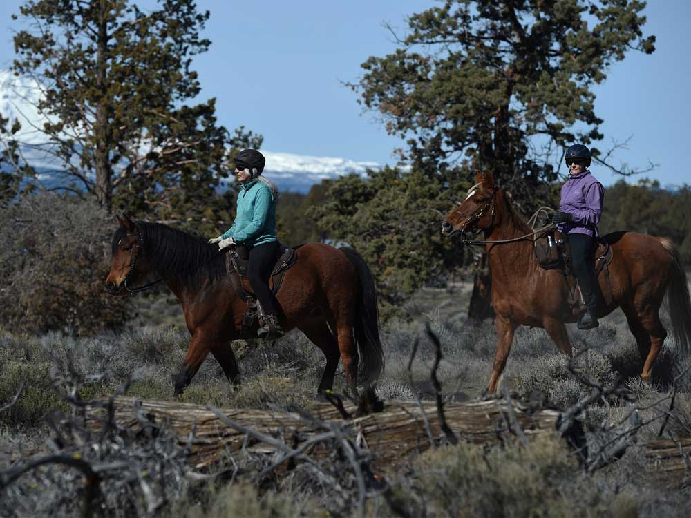
- Sue Turner, left, and Kim McCarrel ride together near the Maston Trailhead off of Cline Falls Highway on March 31. (Ryan Brennecke/Bulletin photos)
When Kim McCarrel recently saddled up Bella, her chestnut-colored Tennessee walker, and set out on a group ride at Maston Trailhead in the Cline Buttes Recreation Area, a mountain biker darted into the periphery. Ears pricked, Bella slowed her trot and trained her attention toward the juniper trees through which the cyclist disappeared. Because cyclists and horseback riders use distinct trails at Maston, however, the encounter was little more than a fleeting annoyance for the mare.
Thanks to a 2009 plan the Bureau of Land Management drafted with the input of land users, including the Central Oregon Trail Alliance and the local chapter of the nonprofit Oregon Equestrian Trails, horse riders and mountain bikers at Maston Trailhead northeast of Tumalo enjoy separate — if sometimes parallel — singletrack trails. Seventeen miles of horse trails and more than 12 miles of mountain bike trails loop through homesteader ruins, located 15 miles northeast of Bend. Tailoring such trails to particular uses enriches Central Oregon’s recreational offerings, McCarrel said.
“We are so lucky because we have so many trails. We have such a variety of riding opportunities,” said McCarrel, rattling off pine forests, juniper groves and rocky badlands as potential backdrops. “Trail riding is a wonderful way to be in nature with my horse.”
The Deschutes National Forest features 13 horse camps — campsites with corrals, water guzzlers and other horse amenities — some whose maintenance Oregon Equestrian Trails and other equestrian groups and activists have assumed. The local Oregon Equestrian Trails chapter, which counts 100 members, adopted Sisters Cow Camp and Swamp Wells Horse Camp, both of which, due to volunteer maintenance, remain no-fee campgrounds. McCarrel, who has authored five Pacific Northwest equestrian guidebooks and is also the Central Oregon chapter chair of the OET, knows that if she and her peers intend to enjoy Central Oregon’s wealth of trails that allow equestrians — minority users among hikers and mountain bikers — they must help lead as stewards of the land.
“If equestrians don’t champion our rights to use the trails, who is going to do it for us? We need to stand up for ourselves and be willing to work cooperatively with the Forest Service and BLM, and with other trail user groups, to resolve issues with respect to trail access,” McCarrel later wrote by email.
In Central Oregon, there are 1,800 miles of trails available to equestrians, mostly on Deschutes National Forest and Bureau of Land Management lands. Most of those trails are dedicated to mixed use. Mountain bikers and hikers who also use them must yield to equestrians.
Each year, there are between 10,000 and 20,000 equestrian visits to Deschutes National Forest trails and five wilderness areas, estimated Chris Sabo, Forest Service trails specialist.
As for many of the BLM trails east of Bend, McCarrel credits the bureau, which manages 400,000 acres in Central Oregon, with spearheading an effort to ensure users have access and sufficient space to recreate in a variety of ways. When recreationists don’t have dedicated spaces, collisions and near-collisions can result in injury. McCarrel spoke anecdotally about horseback riders being particularly vulnerable.
“If a mountain biker rounds a blind corner, there is a horse in front of them — whether they’re going the same direction, it doesn’t matter — it startles the horse, the horse does a 180 (-degree turn), and the horseback rider gets tossed,” McCarrel said. “If you land in a pile of rocks, you’re going to be hurt more than if you fall in a pile of sand.”
The Maston Trailhead, completed in 2012, served as a reference point for subsequent BLM trail projects. Another BLM priority is to streamline the decades-old user-made trail networks that crisscross its jurisdiction, particularly in the Cline Buttes Recreation Area. The bureau is working to install three more trailheads on its perimeter, which presently features five, said Greg Currie, the bureau’s landscape architect. The planned nonmotorized trail development will happen this year and in 2018 in the southern and western parts of the Cline Buttes area. A northern section will be dedicated to off-highway vehicles.
Taking in nature, at a trot
Trail riding, which often happens at a trot (about 4 mph), allows equestrians more time to take in their surroundings. After all, the hoofing is left to the horses. On this particular day at Maston Trailhead, McCarrel and a friend delighted in the sight of junipers filled with swallows. Such observations may be lost on trail users who move at a quicker clip.
Charley Engel, a longtime equestrian activist who is a former member of OET, said when he and his wife bought a ranch house east of Bend in 1986, they were thrilled they were within 3 miles of the nearest trailhead at Horse Butte. However, Engel, who has since salvaged and maintained about 60 miles of equestrian trails around Horse Butte, bristles at the increased popularity of mountain biking on the trails.
“Mountain bikers and horseback people go out for different reasons,” said Engel. “The majority mountain bikers go out to go fast. They want a nice downhill run or they want to ride something really technical and challenging to do. Horseback people travel at a much slower pace; it’s an entirely different vibe. We’re more out there to enjoy the peace and the quiet and the slower pace.”
Soon after a mountain pine beetle infestation wiped out timber in the Horse Butte area in the late ’80s, the Engels spent summers piecing together area trails. They soon joined Oregon Equestrian Trails (which preceded McCarrel’s leadership), with which they adopted and re-established about 60 miles of trails between Horse Butte and the top of Paulina Mountain. The 1996 Skeleton Fire, which burned nearly 18,000 acres east of Bend, including the Horse Butte area, was a mixed blessing to the local equestrian scene.
“(After the fire) it was really bleak country. It took vision on our part to know the forest would recover and it would be another good, popular place (for trails),” Engel said.
The Forest Service used funds from salvaged timber to help OET’s effort to re-establish trails numbered 61, 62 and 63, as well as build new trails. Since then, Engel carried a handsaw and a branch cutter to trim any errant limb. However, he has not ridden in the Horse Butte area in the past five years since mountain bikers have taken to the trail system as a winter holdout until melt-off in higher elevations opens up more popular trail networks.
“Slowly but surely, the mountain bike usage has taken over on trails,” Engel said, who now typically rides with his wife in the Ochoco National Forest. “They’ve displaced horses to the point that I won’t ride trails that I built myself because of the bike traffic.”
Engel, who is no longer an OET member, hosts “Calling All Cowboys,” a “cowboy music” program, twice per week on KPOV. He doesn’t want to disparage an entire group, and acknowledges mountain bike groups such as Central Oregon Trail Alliance have assumed trail maintenance responsibilities. Engel said he has no interest in advocating for exclusive horse trails in the Horse Butte area.
“Why would you go build a new horse trail system when there is already a horse trail system in place?” Engel said. “It would make sense to build a new mountain bike system.”
Bruce Schroeder, a COTA board member who often mountain bikes at Horse Butte, said horses and mountain bikes don’t mix well. He understands how the region’s mountain biking boom may vex long-time equestrians.
“I get their perspective. There are way more winter riders (at Horse Butte) than there were six or seven years ago,” Schroeder said.
COTA and OET have worked together to install and maintain trail markers along Central Oregon’s 150-mile Metolius-Windigo Trail. Schroeder said COTA would be interested in working with OET to create separate trails for horse riders and mountain bikers, but so far discussions are only in preliminary stages.
Sabo, who hikes, mountain bikes and has ridden horses on wilderness patrols, appreciates various trail-user perspectives. As for the ever-popular Horse Butte area, where he recently mountain biked, Sabo said historical perspective can go a long way.
“(The Horse Butte) trails were intended primarily to be used by equestrians. They put in quite a few hours, and they are the stewards of those trails. It’s important for non-hoofed users to be on their best behavior and not to take the attitude that it’s strictly a bike trail. We need to keep that trail courtesy in mind wherever the various uses overlap. Sooner or later, mountain bikers will encounter equestrians.”
— Reporter: 541-617-7816, pmadsen@bendbulletin.com
“We are so lucky because we have so many trails. We have such a variety of riding opportunities. Trail riding is a wonderful way to be in nature with my horse.”— Kim McCarrel, chair of the Central Oregon chapter of Oregon Equestrian Trails
Trail etiquette
Trail courtesy begins with being aware of the variety of ways trails are being used, said Chris Sabo, U.S. Forest Service trails specialist. Hikers and mountain bikers must yield to equestrians. Sabo recommends stepping to the lower side of the trail to let them through safely. He encourages calling out to the riders and speaking soothingly to the horses, as it may minimize the potential for conflict. Those with dogs should leash them in the presence of horses.
“You just never know how a particular horse is going to respond to a nonfamiliar dog,” Sabo said.
Dog leash regulations go into effect along the Deschutes River Trail and some of the high-use trails through Deschutes National Forest wilderness areas, including those of Todd Lake, Broken Top, Green Lakes and Moraine Lake from July 15 to Sept. 15.


Best of the Best of Bend 2025

-
-
-