10 ways to explore Golden Gate National Recreation Area
Published 12:00 am Sunday, February 14, 2016
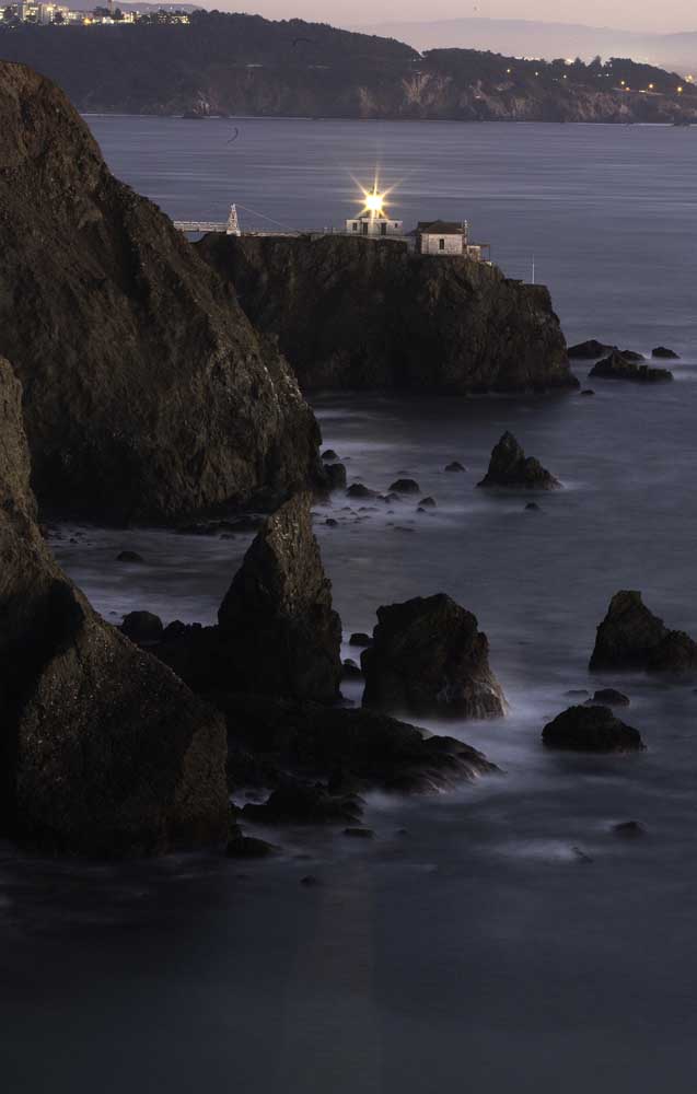
- Dusk settles in along the Marin Headlands and the Point Bonita Lighthouse in the Golden Gate National Recreation Area.
GOLDEN GATE NATIONAL RECREATION AREA, Calif. — The busiest unit in our national park system isn’t a park at all. In fact, plenty of visitors never notice that they’re in it — not when they’re half-lost in the redwoods of Marin County’s Muir Woods, not when they’re deep into a conversation about robots at San Francisco’s Fort Mason, not when they’re roaming the vast beach flats of Fort Funston, near the San Mateo County line.
So be advised: The Golden Gate National Recreation Area is an 80,000-acre non-contiguous realm that flanks the Golden Gate Bridge and includes Alcatraz Island and chunks of three counties. The GGNRA was born in 1972 and since then it’s grown bit by bit into an urban-rural, old-new hybrid that, like many of the national parks, has something for just about everyone.
In many ways, the GGNRA reflects how much the national parks have changed since 1916. In other respects — such as the congressional mandate that the GGNRA’s Presidio area earn enough to pay for its own upkeep — this park unit is like no other. It has public-transit-accessible urban acreage, rural acreage that will require a car (and perhaps a bike or horse) and a legion of old military sites repurposed as lodgings, museums, arts venues, businesses and private residences. It’s got 59 miles of rugged coastline and hundreds of historic buildings, most left behind by the Army. It has traffic problems (not surprising, with 15 million visitors a year). It has forests, beaches, trampolines, high-end hotels, $31-a-night hostels and $5 draft beers with a Golden Gate Bridge view.
To cover all its territory would take months. But if you treat the GGNRA as a travel decathlon — as I did in a pair of recent visits — you can complete 10 feats of tourism, here in no particular order.
North of the Golden Gate Bridge
1: Road tripping, Marin Headlands: After you cross the Golden Gate Bridge, exit at Alexander Avenue, cross under the 101 and turn on Conzelman Road to begin the drive into the Marin Headlands. If you’re on the road at sunset, park at Battery Spencer and take the short path to a Golden Gate viewpoint that puts just about all other scenic bays and bridges to shame.
When you’re ready, drive a mile and a half up the road and park at the Hawk Hill viewing platform, which is buffeted by wind and beloved by birders. If it’s daylight, marvel at the hawks and gulls as they ride the powerful gusts. If it’s getting dark, you may spot the lonely glow of the Point Bonita Lighthouse. And if it’s early afternoon on a Saturday, Sunday or Monday (12:30-3:30 p.m.), the lighthouse will be open and you should head for it. It stands just beyond the end of Conzelman Road at the southernmost tip of the headlands. From the small parking area, you walk past a Nike missile site dating to Cold War days, then head through a tunnel hand-carved in the 1870s by Chinese immigrants, then tiptoe across an elevated walkway. The snug ground floor of the lighthouse is packed with reminders of maritime days gone by. Info: www.nps.gov/goga/marin-headlands.htm; www.nps.gov/goga/pobo.htm
2. Mountain biking, Muir Beach and Dias Ridge: Mountain biking was born in the 1970s a few miles from here in Mount Tamalpais State Park, so why not ramble the Marin hills yourself? I rented a bike ($75 for the day from Bicycle Odyssey in Sausalito) to try the relatively new Dias Ridge Trail. I started at Muir Beach, climbed into the hills on the Middle Green Gulch Trail, followed a 7-mile loop, gained about 1,000 feet in altitude, then zoomed down by way of the Miwok Trail and Dias Ridge, which is open to bikers, hikers and horses. (Part of my route was inside the GGNRA, part outside.) There were views of the hills and the distant Pacific, along with distant glimpses of Muir Woods. Most trail guides call Dias Ridge a moderate ride, but the route kicked my butt. At trail’s end (Muir Beach again), you can rest and recuperate at the Pelican Inn, a neo-Elizabethan pub in which many a mountain biker has downed many a pint. At the Muir Beach Overlook, a bluff top you can reach by hike or car about a mile west of Muir Beach, there’s a great panorama of raw coastline, with almost no signs of civilization. Info: www.nps.gov/goga/planyourvisit/muirbeach.htm
3. Horseback riding, Tennessee Valley: Saddle up at Miwok Livery Stables (415-383-8048, www.miwokstables.com) in the Tennessee Valley, about 4 miles northwest of Sausalito, and soon you’ll be clopping along in the middle of rolling hills and old dairy farms. The Marincello Trail, named for a thwarted real estate development that would have added 30,000 residents to the area, is one of three riding options from the stables, which has 42 horses. Led by instructor Kendall Robinson-Clarke, photographer Brian van der Brug and I spent an hour riding out and back on Old Springs Road ($100 per person), savoring peekaboo views of the sea and city skyscrapers. I especially liked the way Robinson-Clarke firmly instructed passing mountain bikers to stop and walk their bikes past us.
4. Tree gazing, Muir Woods: The redwoods here are ancient and enormous. But be warned: Muir Woods National Monument isn’t all that big, and there isn’t much parking, which means that cars park up to 2 miles away alongside the narrow county highway. Yet once you’re inside, look up into that soaring canopy and cast your mind back 110 years. That’s when Marin County philanthropist William Kent bought a grove 12 miles north of the Golden Gate and donated 295 acres of old-growth trees to the federal government. Since then, the grove was named for John Muir, designated a national monument, expanded to 558 acres and incorporated into the GGNRA. There are only 6 miles of trails in the woods, but a creek burbles through, and together, the trees make a secular cathedral that smells of damp bark. In coming weeks, the National Park Service and county officials will ban some roadside parking. Arrive as close to the 8 a.m. opening time as you can or catch a Marin Transit shuttle bus from a nearby pickup point. Info: www.marintransit.org/routes/66.html
5. Discovering, Fort Baker: This 335-acre chunk of land just north of the Golden Gate Bridge was an Army base from 1866 to 1994 and was added to the GGNRA in 2002. You can take your young kids to the neighboring Bay Area Discovery Museum (www.baykidsmuseum.org). Or work up a thirst with a mile-long loop hike on Drown Road and the Chapel Steps Trail, which starts with a climb through a eucalyptus grove near the museum (www.parksconservancy.org/visit/park-sites/fort-baker.html). Thirsty now? Head to the far end of the parking lot, where Travis Air Force Base still operates a small marina and bar on the east side of Horseshoe Bay. Open to the public Thursdays through Sundays, the Travis Marina Bar, aka Presidio Yacht Club, is easy to miss. But inside, some tables offer priceless views of the Golden Gate Bridge.
South or east of the Golden Gate Bridge
6. Escaping to Alcatraz: This place has been a tourist attraction for longer than it was a federal prison — 42 years versus 29. Ferry tickets sell out weeks in advance and they aren’t cheap; the round trip from San Francisco’s Pier 33 costs $31-$38 for adults. The history concentrated on the island’s 22 acres is richer than you can imagine, including the island’s first use as a military installation in the 1850s; the imprisonment of Native Americans there in the 1890s; the involuntary residence of Al Capone, the Bird Man and others; and finally its addition to the national park system in 1973. Lately, it’s been drawing visitors of a different stripe. After the success of artist Ai Weiwei’s installation on political prisoners there in 2014-15, Alcatraz’s light-filled, splendidly dilapidated New Industries Building is likely to become a prime venue for art displays. The current show (through June) is “Prisoners of Age,” a striking collection of 60 photographs by Ron Levine accompanied by quotes from American and Canadian convicts who are senior citizens. Info: www.alcatrazcruises.com
7. Feeding the mind, Fort Mason: Since the 1970s, this former Army port of embarkation on San Francisco’s waterfront has been a haven for arts, education and cultural organizations, including the Museo Italo Americano, the Mexican Museum, art galleries and a couple of theaters, one of which offers improv shows on Friday and Saturday nights. If you’re a more contemplative soul, step into the Interval, a bar/cafe opened in 2014 by the nonprofit Long Now Foundation. Outfitted with tall bookshelves, strange metal devices, a cozy bar and a chalk-drawing robot named Otto, the 49-seat space is Long Now’s way of starting conversations about long-term thinking. On the night I visited, Kirk Citron was lecturing on the decline of disease, the rise of robots and the unwarranted pessimism and short-term thinking of traditional news outlets. “If I could choose to be born any day in the last 10,000 years, I would choose today,” he said. Info: www.fortmason.org
8. Engaging activities, the Presidio: At this big, mostly green, 1,491-acre space surrounding the southern base of the Golden Gate Bridge, Spanish soldiers set up shop in the 18th century, followed by the U.S. Army in the 19th and 20th centuries. (The land passed from the Army to the NPS in the 1990s.) Nowadays it’s one of the busiest parts of the GGNRA, a place where you can ride a bike; hike; golf; practice rock climbing; bowl; browse the Walt Disney Family Museum; check out works by environmental artist Andy Goldsworthy; take batting practice; or bounce on trampolines for $14 an hour at House of Air by Crissy Field, a former U.S. Army airfield. The Presidio sets aside its Main Post lawn for Off the Grid food truck picnics on Sunday afternoons and Thursday nights from spring through early fall (www.offthegridsf.com). You can also trace the Presidio’s history at an exhibit inside the old Officers Club. If you’re on two wheels, make your way to Fort Point, an 1850s brick-and-granite relic that hunkers under the south base of the Golden Gate Bridge. Your next move is to bid goodbye to the GGNRA for the moment, pedal across the bridge and return by ferry. Info: www.presidio.gov
9. Exploring, Sutro Baths: It’s not Machu Picchu, but the site of Sutro Baths, on San Francisco’s west coast near the end of Geary Boulevard, is worth your archaeological exploration. In the 1890s, developer Adoph Sutro built seven swimming and soaking pools right at the ocean’s edge. They were a big hit. And then they weren’t. Over decades the baths deteriorated, and in 1966 there was a fire. Seven years later, when the GGNRA was created, the concrete Sutro ruins became part of the newly protected territory. It’s a kick to pick your way around the pools and crumbling walls and sea birds. But respect the waves — they get big.
10. Beachcombing, Fort Funston: By car, follow the Great Highway south along the shore and stay right as it turns into Skyline Boulevard. That route takes you to Fort Funston, where hang-gliders fly from 200-foot, ice-plant-covered coastal bluffs. Near the bluff-top observation platform, a steep sand-ladder path (planks connected by steel cables) winds down to another mile or so of wide beaches. On the day I visited, no one was in flight, but a bevy of dogs and dog-walkers scampered in the sand and shallows. I climbed down, turned left and soon was meandering among a dozen old pilings from some long-ago pier. The place felt like the end of the Earth, but no, it’s just another far corner of that territory known as the Golden Gate National Recreation Area.


Best of the Best of Bend 2025

-
eEdition

-

-
Go! eEdition