Editorial, B4 Obituaries, B5 Weather, B6
Published 12:00 am Wednesday, October 23, 2013

- Rachelle Lemmon
In the wake of a Dec. 30 tour bus crash that killed nine, we set out to assess whether Interstate 84 from Pendleton to Ontario deserves its notoriety.
By Jayson Jacoby
WesCom News Service
The best way to get around in Oregon’s northeast corner is on a route that’s prone to some of the region’s worst weather.
This paradox of Interstate 84 has earned the four-lane freeway — the most direct route between Portland, Boise and Salt Lake City — a widespread reputation for difficult driving conditions and frequent weather-related closures between Halloween and, occasionally, Memorial Day.
The section most notorious for inclement weather is the 168 miles through the Blue Mountains between Pendleton, in the Columbia River Basin, and Ontario, beside the Snake River on the Oregon-Idaho border. This part of I-84, which roughly parallels the route of the historic Oregon Trail, passes La Grande and Baker City, the two largest cities between Pendleton and Ontario.
It also includes perhaps the most misleadingly named place in the whole region, said Rachelle Lemmon, who drives buses for the Baker School District. That’s Pleasant Valley.
The area, about eight miles south of Baker City, has neither steep grades nor sharp curves. But its microclimate makes it prone to snow and, especially, ice, when the freeway on either side is clear.
“There’s nothing pleasant about it, at least during the winter,” Lemmon said.
A vital corridor
I-84, in addition to its importance for local residents, is a vital commercial pike, with trucks making up about 43 percent of the traffic, a much higher percentage than for other sections of interstate highway in Oregon.
It’s also one of the more scenic pieces of interstate in Oregon, passing through the pine and fir forests of the Blue Mountains. The area’s recreational opportunities, which include hunting, fishing and the nearby Eagle Cap Wilderness, Oregon’s largest backcountry area, attract visitors from across the nation. And many of those drivers live in places where gentle terrain and temperate weather predominate.
“There are a lot of people from out of state who don’t know what these mountains are about,” said Wendee Morrissey, a bus driver for the Baker School District for 27 years. “We only do 55 mph. People see that big yellow bus and think they just have to get around that.”
Dangerous sections
The route through the Blues is infamous not only for its weather but also for its topography, which posed some of the more daunting challenges for 19th century pioneers in ox-drawn covered wagons. In contrast to the generally flat terrain which the freeway, and the Oregon Trail before it, traverses in the 200 miles between Portland and Pendleton, the section through the Blues includes:
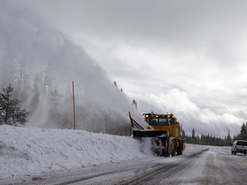
• Four grades of 5 percent or 6 percent, among them Cabbage Hill just east of Pendleton, where the westbound lanes plunge almost 3,000 vertical feet from the mountains into the Columbia Basin in a series of corners.
This is one of a handful of highways in Oregon where the Oregon Department of Transportation built emergency “escape ramps” — uphill lanes carved into the slope beside the highway where truck drivers can stop should their brakes fail on the five-mile descent.
The heaviest commercial trucks are urged, by a series of signs, to not exceed about 18 mph, lest their beleaguered brakes overheat. In summertime, ODOT fills 50-gallon metal barrels with water for drivers to use to refill radiators that have boiled over on the eastbound ascent.
“You always have to be prepared for those steep hills,” said Sandy Fuller, who commutes two or three times per week from her home in Weiser, Idaho, to Marvin Wood Products in Baker City, a 65-mile route that includes about 50 miles of I-84 between Farewell Bend and Baker City.
Fuller also drove the Cabbage Hill section frequently when she was living in Milton-Freewater and attending Eastern Oregon University.
• The second-highest pass of any freeway in Oregon — 4,193-foot Blue Mountain summit near Meacham, between Pendleton and La Grande.
• Ladd Canyon, a breach in the basalt mountains between Baker City and La Grande that acts as a natural wind tunnel, creating occasional whiteouts that can constrict travelers’ visibility to a couple of car lengths.
“I don’t think Ladd Canyon’s reputation is overrated,” said Lemmon, who frequently hauls Baker High School sports teams to La Grande via I-84.

Best of the Best of Bend 2025

-
-
-