Hiking on the McKenzie River
Published 12:00 am Wednesday, March 19, 2014

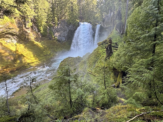
- Mark Morical / The BulletinThe McKenzie River Trail meanders through old-growth Douglas fir trees in the Willamette National Forest.
The McKenzie River has always filled me with a certain mystical wonder about its hidden beauty.
Perhaps that is because most of the times I see the river I am trying to sneak a peek at it from the highway as I drive from Bend to Eugene for University of Oregon football games.
The McKenzie in the fall is undeniably breathtaking — when fiery red, gold and orange leaves line the clear, rushing river.
The McKenzie in the late winter and spring is just as alluring, albeit for a different reason — the waterfalls that are a main attraction of the river are gushing in all their glory.
Last week I made the hourlong drive from Bend to Sahalie Falls, which was spilling with such brute force that even from my viewpoint near the parking lot I was soon covered in a fine mist. A bright rainbow formed near the base of the falls.
Tucked into the rugged, lush western slope of the Cascade Range between Central Oregon and Eugene, the McKenzie River National Recreation Trail has long been a favorite for mountain bikers. But I did not bring my bike along on this occasion. Instead, my plan was to hike the Waterfalls Loop Trail, which incorporates a section of the McKenzie River Trail (MRT) but is on the east bank of the river and is restricted to foot traffic.
From the viewpoint, I took the trail north up to the brink of the 120-foot-high Sahalie Falls, where more mist floated into the ether like steam from a locomotive. From the falls, the hiker-only trail took me deep into the old-growth Douglas fir trees of the Willamette National Forest.
The trail is situated at about 2,800 feet in elevation, so I had wondered about snow and accessibility issues. Sure enough, snow covered portions of the trail, but it was fairly easy to avoid. Mountain bikers might need to wait a few more weeks, however, as negotiating snow on a bike is much more challenging than on foot.
I crossed a bridge to the west side of the river where the Waterfalls Loop Trail connects to the MRT. Other tiny waterfalls gurgled above the trail as I turned back south toward 90-foot Koosah Falls, the other waterfall that makes this section of the river such a draw.
The MRT between Sahalie Falls and Koosah Falls is covered in lava rock, making it extremely technical and challenging on a mountain bike. I was relieved to be on foot. I have biked the MRT many times, but it was a welcome change of pace to hike this section of trail. Being on foot allowed me to really absorb all the subtle intricacies that make the trail so impressive: moss-covered boulders, deep blue pools of the river, and impossibly giant Douglas firs.
The MRT is built in such a way that hikers can stand just a few feet from the brink of Koosah Falls. At a viewpoint farther down the trail, the waterfall seems to suddenly appear out of the darkness of the forest.
Both Sahalie and Koosah waterfalls were formed by lava flows from about 3,000 years ago, according to the U.S. Forest Service. Sahalie is a “segmented” waterfall, meaning the stream diverges into two or three sections as it cascades. Koosah is a “block” waterfall, which descends as a single wide breadth.
I continued along the trail, downstream of Koosah Falls, taking in all the greenery that makes the area so different from trails in Central Oregon. While mud is often a deterrent at this time of year on hiking and biking trails closer to Bend, the MRT does not seem to have that problem. The trail in mid-March was wet and tacky, but not at all muddy or sloppy.
My original plan was to complete the 3-mile waterfall loop, but when I came to Carmen Diversion Reservoir, I decided to continue on along the MRT for a couple more miles.
After a while, I turned around to head back to Sahalie Falls, following the bridge near the reservoir to get back to the east side of the McKenzie River.
I walked past Koosah Falls again on my way to Sahalie. The hiker-only part of the loop (the east side) is a noticeably easier trail than the rock-covered trail on the west side of the loop.
By the time I returned to the parking area at Sahalie, I had hiked about 6 miles. The entire McKenzie River Trail is 26 miles, from its north end near Clear Lake (the headwaters of the McKenzie) to its south end near the McKenzie Ranger Station. Thousands of hikers and bikers run or hike the trail from end to end each year from the spring through the fall.
The waterfall section is maybe the most impressive part of one of Oregon’s most revered trails. But you could spend weeks unlocking the many secrets of the McKenzie.
— Reporter: 541-383-0318, mmorical@bendbulletin.com

Best of the Best of Bend 2025

-
-
-