What’s a Fuzztail? Why, it’s a Central Oregon butte.
Published 12:00 am Wednesday, November 5, 2014

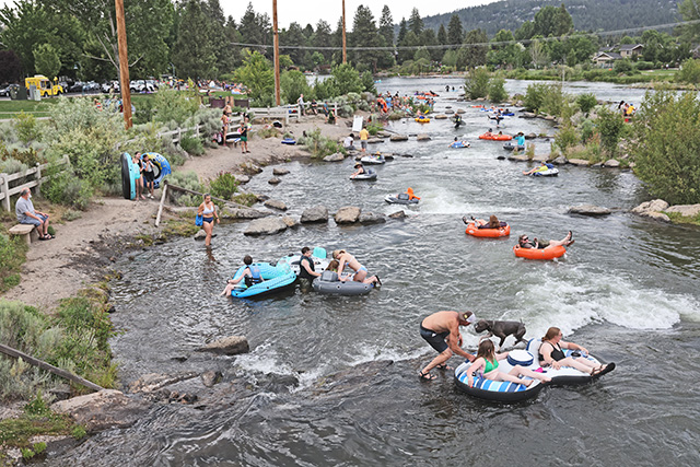
- David Jasper / The BulletinIn this image looking to the northwest, the nearly treeless flank of Bessie Butte is visible, with Black Butte rising behind it. These and a lot of other Central Oregon prominences can be seen from Fuzztail Butte, located southeast of Bend in the Swamp Wells area.
Right on schedule, snow has begun piling up in the hills west of Bend. And while we (may) have a month or more to wait for snow-riding, it’s in our near future.
Just be patient, grasshopper.
The question is how can you best distract yourself during the shoulder season?
Raking leaves is always a blast. You could train for cross-country skiing by donning a pair of those roller skis and taking to the road, though small-minded people like me will probably make fun of you.
A few snowboarders I know have been venturing out on early-morning hikes to the top of Mount Bachelor to get their quads in shape for the season. You could take a cue from these die-hards, but keep in mind they’re training for the Dirksen Derby rally race in mid-December.
If you’ve already raked all the leaves, the sight of roller skis make your eyes roll involuntarily, and the only list “summiting a mountain” is at the top of is a list of things you’d never under any circumstances want to attempt, have hope; you can always hike a butte. Still good for the old quads, minus the hassles of altitude sickness and avalanche beacons.
A butte is what Map Guy and I went for Thursday after he came through with a bona fide outing idea. He usually balks when I hit him up for suggestions, mumbling something about how I’m the leader, he’s just along for the ride, etc.
But at the last minute, I remembered that the trail I’d wanted to hike — the criminally ignored and underappreciated Black Rock Trail — was under repair, according to a brief that ran a couple of weeks back in this section.
As we sat studying maps in my kitchen, Map Guy piped up, “How about Fuzztail Butte?”
“Fuzztawhat?” I said.
He explained the 5,734-foot butte’s approximate whereabouts, southeast of Bend in the China Hat area, nestled among the many buttes that pepper the region.
I didn’t need much convincing, so I quickly tried to origami the maps back into shapes resembling rectangles, grabbed some snacks, water, my mutt Kaloo, and we took off.
It occurred to me I hadn’t been out China Hat way in a long while, other than maybe a couple of let’s-get-out-of-the-house-before-the-inertia-becomes-toxic moments with various family members, which often finds us making our way to Swamp Wells Trail or Bessie Butte.
If you know the area, you know that those horse, bike and hiking trails east of town get mighty hot in the summer, the loose, sandy soil becoming much more of a slog in the hot months. So from about May through October, cooler minds prevail by heading to places that have shade, water and firm turf. Go figure.
Now that it’s November and the weather is starting to resemble fall, we’re nearing that welcome time of year when the outdoor delights east of Bend once again become options for outside fun, the trails benefiting from increasing moisture and decreasing temperatures.
Now, if you know where Bessie Butte is, off Forest Road 1810, you’re in the neighborhood. We followed signs for Swamp Wells Horse Camp, taking 1810 to 1816. Instead of going all the way to the horse camp, though, we hung a left about a mile shy of the camp, parking at the base of the butte at a faded sign that read 500.
The trail is more of a four-wheel-drive road (some maps call the rough road to the top a Jeep road, but that seems unfair to other vehicles and their owners’ self-esteem). Map Guy kept insisting that his Toyota rig could have absolutely made the drive to the top, but then that wouldn’t have made for much of an outing.
Map Guy wore a backpack, as prepared as any scout trying to earn his next badge, but it seemed a little much considering the hike to the top had to be a few hundred yards shy of a mile. At over 5,000 feet, we were into a nice stand of pines, with plenty of bitterbrush and manzanita for ground cover.
The steep ascent of the trail got the lungs doing a little extra work, but the views improved as we gained elevation. At the top, we shared our respective water bottles with Kaloo by pouring a little in a rock with a crater in it.
Fuzztail is nestled between Lava Top Butte to the north and Swamp Wells Butte to the immediate south. The sightseeing is without compare. You can keep your map to the stars’ homes. I’ll take this kind of sightseeing.
We spent a good 30 minutes up there gawking and arguing about whether or not that one over there was Bessie, that one was Kelsey and that little one due west was Lava Butte. (Note, in all cases, I was correct.)
One of the buttes we could see was Luna Butte, which I hiked this year with Kolby Kirk, an area artist, writer and hiker who’s at work on a guidebook project to area buttes. So I hit him up for some information about the name Fuzztail.
“Legend has it that a horse was found nearby, leading to the name. Wild horses were nicknamed ‘fuzz tails’ due to the raggedy condition of their tail hair,” he replied. Works for me.
Of course, there was really no point in my arguing with Map Guy about the names and locations of buttes: The views were beautiful no matter what you call them. It was not the clearest of days, but we could still see as far away as Mount Jefferson, along with Horse Ridge and other High Desert sights.
I say this all the time, but I’d definitely return here. More realistically, I’d probably skip it and check out the view from one of the other buttes in the vicinity.
On the way back down to Map Guy’s truck, Kaloo was his usual part-border collie self, running ahead of us, then backtracking to make sure we were still alive.
We were. Maybe a little more so than usual.
— Reporter: 541-383-0349, djasper@bendbulletin.com


Best of the Best of Bend 2025

-

-
-