Wintertime in La Pine State Park
Published 12:00 am Wednesday, January 15, 2014
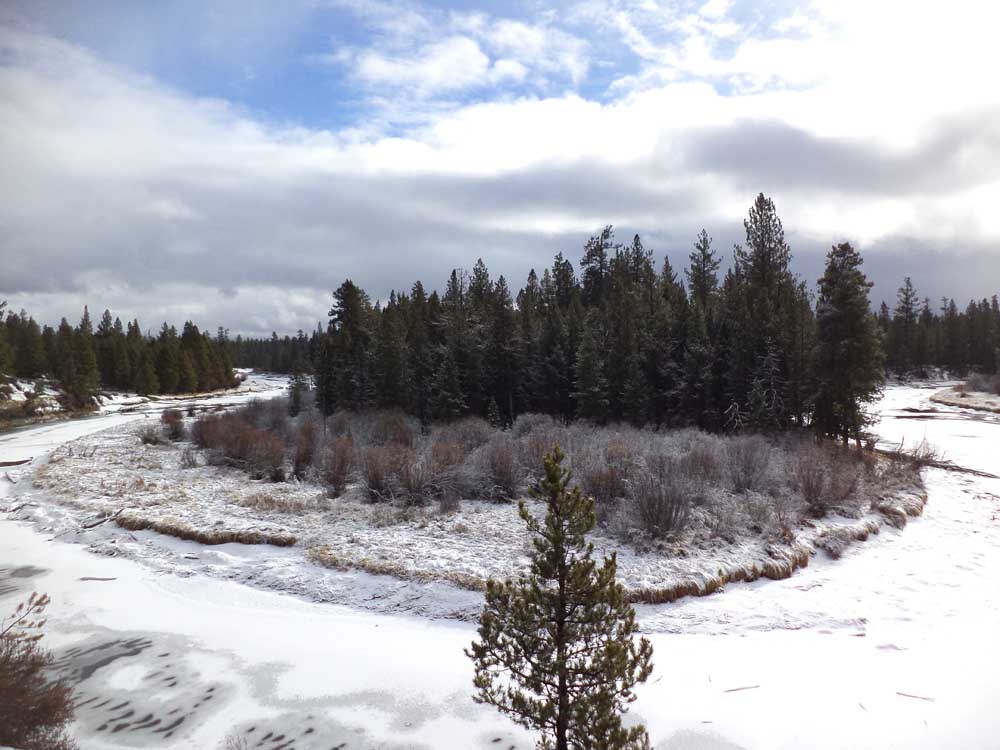
- Photos by David Jasper / The BulletinMcGregor Memorial Viewpoint in La Pine State Park affords a great view of the Deschutes River.
Welcome back, winter. Better late than never.
That was my thought after Map Guy and I visited La Pine State Park, an easily overlooked bit of forest through which the Deschutes and Fall rivers wind.
Sometimes a leisurely paced walk through the woods is just what the doctor ordered. Even when you haven’t gone to the doctor.
Last Tuesday, during one of my family’s nightly dinner-table debates — more heated than any meal ever could be; why can’t we just watch TV like a normal family? — my neck and upper back locked up tight as a drum in a safe at Fort Knox.
Anything could have caused it: I had loaded my heavy commuter bike into the back of my low-slung car that morning to have it worked on at a bike shop. I used a stability ball most of my workday for the first time. I went running for the third time in four days, which is a lot for me. Or maybe it was just the stress-inducing conversation.
Well into Wednesday, I could barely turn my neck. Just rolling over or sitting up in bed was torture, or at least enhanced interrogation.
An old Facebook friend who works as a physical therapist diagnosed (from a 3,000-mile remove) a disc injury, which struck me as odd because I hadn’t played disc golf in ages. She advised a doctor’s visit, physical therapy and Aleve.
One out of three isn’t bad: I took her up on the Aleve. In my past experience, whatever malady or injury sparked a medical appointment has usually disappeared or mended by the time the first available appointment rolls around six weeks later (on average).
The Aleve was helping, but there was no way I would be up for riding a mountain bike or cross-country skiing with Map Guy, which, along with arguing, are two of our favorite Outing activities.
Map Guy also requested we do something mellow, as in an easy hike, because he is temporarily between health insurance policies. Turns out neither of us was up for a long but rewarding journey, testing our physical limits or visiting doctors.
It was settled then: An easy hike it would be. There are lots of places to do that, so why couldn’t I think of any? In the past few months, I’d done outings to Fall River, Boyd Cave, Benham Falls and the Smith Rock area. We talked about Fort Rock or Hole in the Ground, but neither of us felt like taking such a long drive. Where the heck were we going to go?
La Pine State Park, that’s where. It’s a relatively short and easy 27-mile drive south of Bend, although longtime Bendite Map Guy went on and on about how U.S. Highway 97 used to be called “The Ribbon of Death” back in the good ol’ days. Nothing like a vivid reminder of mortality to remind you why one should drive carefully, especially when there’s a dusting of snow atop ice from the previous night’s rain. We definitely drove over some black ice en route to the park.
After passing Sunriver, we turned right and headed west about 6 miles on State Recreation Road. We planned to hike, and I figured we’d set out from the Big Tree — biggest ponderosa in Oregon! — but alas, that way was gated off for the winter. So we drove deeper into the 2,333-acre park until we reached a sign and lot that said “trailhead” and took off on foot. (Note: The lot is just before the bridge over the Des-chutes River.)
The path we followed hugged what I initially thought was the Deschutes. A Google satellite map labels it as “The Dead Slough,” an oxbow bend that looks largely cut off from the main part of the Deschutes River but is no less pretty to look at.
There was a thin blanket of fresh snow on the ground, giving the pines and bunch grasses a sorely needed wintry coat. Because of the paucity of visitors on a Thursday morning, we were treated to unmarred animal tracks crossing the trail — mainly rabbit, squirrel and my hyperactive dog’s. We ruined the tranquility with our usual mix of talking and ribbing each other, punctuated here and there by a thrown snowball whenever we were near a fence or sign or picnic table with enough accumulation to allow the making of a snowball.
The trail took us to the edge of the parking area for the Big Tree and a sign telling us it was another 1,000 feet down the trail.
After just a ¾-mile hike all told, we were there, gawking up at the spectacle of one big old ponderosa tree. Oddly enough, Map Guy had never seen it before. The tree is an estimated 500 years old, with a height of 162 feet and diameter of 8.6 feet. Not that you can get close enough to measure it. It’s fenced off because of foot traffic and the soil compaction caused by inquisitive feet, but also “to maintain its visual uniqueness,” as it’s profoundly worded on a nearby sign.
If my neck were working, I’d have craned it to look up at the tree. Instead, I took in the many gnarly knots boiling up from its lower trunk. One thing’s for sure: That scarred-up tree looks like it has earned every one of its 500 years. Meanwhile, the insouciant Map Guy, who visited the California redwoods a short while back, acted unimpressed.
We continued down the trail, a short loop that would take us closer to the edge of the Deschutes, then up a short hill that affords a view of the river and a mansion on the other side. Map Guy was seriously perturbed by its presence, marring the view. I agreed it was bigger than most people require, but I wasn’t half as indignant about its existence because I chose to look at the trees, water and scenery in the other 97 percent of my field of vision.
We ended up back at the top of the 1,000-foot path, then took the trail we’d come in on back toward the car. The walk back was quick, mostly because we threw snowballs the entire way. It was a welcome distraction from the back pain I’d experienced the last day and a half, and I swear to you my back felt better for the exercise, even if it was just walking in the woods and throwing snowballs.
I’m sure we were quite a sight as we walked along — two ostensible grownups throwing snow like a couple of kids walking home from the bus stop — or we would have been if we hadn’t had the trail all to ourselves.
Back at the car, we decided to drive farther down the park road, getting out at McGregor Memorial Viewpoint, still another great bit of scenery looking down at the partly frozen Deschutes and snow.
All told, a wintertime visit to La Pine State Park is well worth the time invested in getting there. Getting in a snowball fight is just a bonus.
— Reporter: 541-383-0349, djasper@bendbulletin.com

Best of the Best of Bend 2025

-
-
-