Oregon’s scenic byways
Published 12:00 am Sunday, January 5, 2014
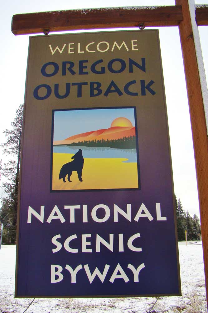
- John Gottberg Anderson / For The BulletinJust south of La Pine, a signpost indicates the west end of the Oregon Outback National Scenic Byway.
Oregon is unique in the National Scenic Byways Program. Only one state (Colorado) has more designated byways than Oregon’s 10, but our state also has the nation’s original scenic byway: the Historic Columbia River Highway.
Established by Congress in 1991, managed under the aegis of the U.S. Department of Transportation by the Federal Highway Administration, the National Scenic Byways Program intends to promote tourism and economic development through protection of scenic but often less-traveled routes. To qualify for inclusion, the road must display at least one of six intrinsic qualities: archaeological, cultural, historic, natural, recreational and/or scenic value.
Some are designated as All-American Roads. These routes must be considered unique in the United States; they must present at least two of the half-dozen essential qualities and be tourist destinations in themselves.
Of Oregon’s 10 scenic byways, four are All-American Roads, twice as many as Colorado (which has 11 byways). California, New Mexico and Utah each have eight scenic byways, Washington seven, Idaho six. In all, the U.S. features 150 National Scenic Byways, including 31 All-American roads, in 46 states.
These are Oregon’s National Scenic Byways, beginning with its All-American Roads — the Historic Columbia River Highway, the Pacific Coast Scenic Byway, the Hells Canyon Scenic Byway and the Volcanic Legacy Scenic Byway.
Although not all of these 10 roads are recommended for travel in the winter season, it’s not too soon to start planning an excursion for later in 2014.
All-American Roads
Columbia River Highway
Stretching 75 miles from Troutdale to The Dalles, the first planned scenic highway in the United States was built through the Columbia River Gorge between 1913 and 1922. When finished, the highway introduced modern tourism to the Pacific Northwest. Campgrounds, roadhouses and stately lodges catered to motorists, and elegant structures like Vista House provided sheltered panoramic views of the gorgeous gorge.
“Our first business was to find the beauty spots,” wrote engineer Samuel Lancaster, “and if possible to locate the road in such a way as to reach them.” The crews excelled at their mission of showcasing waterfalls and other points of interest. Working together with transportation attorney and entrepreneur Sam Hill, who had established a small Quaker colony above Maryhill, Lancaster and his team gained financial support from many Portland civic leaders of the era.
Without the benefit of computers or modern equipment, the crews of men and horses laid down a road that was far more than a mere strip of blacktop. Tunnels, bridges, ornate masonry, white wooden guardrails and concrete mileposts marked every section of the route. When the U.S. highway system was created in 1926, the highway became a section of U.S. Highway 30. And although some architectural elements were lost when Interstate 84 was built parallel to the highway in 1960, historic preservationists have succeeded in restoring many of them.
Today, 40 miles of the historic highway — a designated National Historic Landmark — are open to motor vehicles. Beginning in Troutdale at the west end of the Sandy River bridge, the first 24 miles of the route weave past the stunning Chanticleer Point scenic viewpoint and the historic Vista House at Crown Point State Park, 733 feet above the Columbia River. It also passes numerous spectacular waterfalls including Multnomah Falls, second highest falls in the United States, plunging 611 feet in two cataracts.
For the next 34 miles, from Ainsworth State Park through Cascade Locks and Hood River, the Historic Columbia River Highway is inaccessible to cars. Under development as a trail for hikers and bicyclists, it includes a 7-mile stretch through a pair of tunnels between Hood River and the village of Mosier. The final 16 driving miles, from Mosier to The Dalles, rise through the wildflower-rich Tom McCall Preserve and over Rowena Crest, with a descent along a series of graceful switchbacks known as the Rowena Loops.
Pacific Coast Byway
This beautiful coastline drive takes in the full extent of U.S. Highway 101 down the Oregon Coast, 363 miles north-south from the Columbia River, at Astoria, to the California border south of Brookings. En route, it follows long rocky beaches and clings to seaside cliffs, passes picturesque lighthouses and derelict shipwrecks, passes miles of wind-sculpted sand dunes and more than 50 state parks and recreation areas, and visits dozens of charming communities — some of them tourist towns, others with bustling fishing harbors.
The road can be divided into northern, central and southern sections. The north coast begins in the historic Columbia River city of Astoria, at the foot of the Astoria-Megler Bridge linking Oregon and Washington. It was near here that the Lewis and Clark Expedition spent the winter of 1805-06 at Fort Clatsop, now the hub of Lewis and Clark National Historical Park. A short drive south and just a few miles apart are Seaside, which recalls memories of circa-1900 resort towns, and Cannon Beach, a modern arts community. From the dairy-farming center of Tillamook, many drivers detour around the picturesque Three Capes Scenic Route, rejoining U.S. 101 just past the surfing center of Pacific City.
The central coast begins where U.S. 101 descends into Lincoln City. The coast’s busiest tourist center, Lincoln City strings for 7 miles along the highway. Further south, amid rugged headlands, is the whale-watching capital of Depoe Bay. Then comes Newport, famed for its bustling Yaquina River harbor and the Oregon Coast Aquarium. Near Yachats, Sea Lion Caves protect a remarkable grotto whose scores of denizens maintain a constant roar. The Oregon Dunes National Recreation Area, 50 miles in length, extends from the Siuslaw River harbor town of Florence and across the mouth of the Umpqua River at Reedsport, terminating at Coos Bay, the largest coastal harbor between Puget Sound and San Francisco Bay.
Now travelers are on the southern coast. Once a major logging port, the city of Coos Bay remains a working-class community proud of its blue-collar history. A side road extends out the Charleston Peninsula to dramatic Cape Arago, while the main route proceeds to Bandon, renowned for its Bandon Dunes golf resort. Coastal scenery remains dramatic around Cape Blanco, with the coast’s most beautiful lighthouse, and through Port Orford and Gold Beach, from where jet boats travel up the Rogue River. The California redwood country begins 7 miles past Brookings.
Hells Canyon Byway
There’s competition for the honor, but Hells Canyon — through which the Snake River flows along the border of Oregon and Idaho — makes claim to being the deepest gorge in North America. At 7,900 feet, it’s half again deeper than Arizona’s Grand Canyon. Whether it is of greater depth than California’s Kings Canyon is up for debate. The beauty of the road is not disputed.
Extending between the cities of La Grande and Baker City, looping around the Wallowa Mountains and across a ridge with views into the chasm, the Hells Canyon Scenic Byway extends through 218 miles of northeastern Oregon. Starting up state Route 82, it circles the lofty Wallowas, including the Eagle Cap Wilderness, and passes through the delightfully remote town of Joseph, famed for its bronze foundries. Cresting at isolated overlooks of the canyon, it then descends via national forest roads to the Oxbow Dam, continuing west on state Route 86 to Baker City along the weathered track of the historic Oregon Trail.
Volcanic Legacy Byway
The highlights of the most dramatic volcanic activity in the lower 48 states may be visited along this route, which extends through Crater Lake National Park, around California’s Mount Shasta to Lassen Volcanic National Park, with a spur road into Lava Beds National Monument, just south of the Oregon border. The full itinerary is about 500 miles long.
In Oregon, the Scenic Byway begins at Crater Lake Junction, south of Chemult on U.S. Highway 97. Following a series of state highways — 138, 209, 62 and 140 — it enters Crater Lake National Park at its north entrance, circles the caldera on spectacular Rim Drive, and follows the shoreline of Oregon’s largest lake, Upper Klamath Lake, to Klamath Falls. There the byway rejoins U.S. 97, offering a short detour to the world-class birding of Lower Klamath National Wildlife Refuge before crossing into California.
Other National Scenic Byways
Cascade Lakes Scenic Byway
Beginning in Bend is the Cascade Lakes Scenic Byway, which runs 66 miles (along Century Drive and Forest Route 46) southwesterly to state Highway 58 near Crescent Lake. Extending between the Three Sisters Wilderness and Mount Bachelor, it showcases the alpine scenery, pristine lakes and pine forests for which this region is known, with outstanding examples of volcanism and glaciation in its lava flows and wildflower-rich mountain meadows.
While the designated Scenic Byway extends south past Crane Prairie Reservoir and Davis Lake to its terminus near Willamette Pass, day trippers may choose a shorter route, returning east to U.S. 97 at Sunriver by following the upper Deschutes River past Wickiup Reservoir.
McKenzie Pass-Santiam Pass Scenic Byway
Another readily accessible route for Central Oregonians is the McKenzie Pass-Santiam Pass Scenic Byway, an 82-mile loop drive that begins and ends in Sisters. This circuit, however, may be traveled in its entirety only in summer, as state Route 242 over McKenzie Pass is closed by snow for half the year or longer.
With dramatic views of the Three Sisters, Mount Washington, Three Fingered Jack and other Cascade peaks, capped by glaciers even in late summer, this tour route climbs past cobalt-blue Suttle Lake on state Highway 126 to Santiam Pass. It then descends past several striking waterfalls, including Sahalie and Koosah falls, on the upper McKenzie River before reaching the village of McKenzie Bridge. Here the route turns onto state 242, ascending through dense Douglas fir forests to lava fields atop McKenzie Pass, where the Dee Wright Observatory affords memorable views of mile after mile of basaltic rock spewed from Cascade volcanoes.
Mount Hood Scenic Byway
The 105-mile Mount Hood Scenic Byway begins and ends at the Historic Columbia River Highway. Circling the south side of Mount Hood via Government Camp, it extends from the old highway’s midpoint, at Hood River, to Troutdale via state Route 35 and U.S. Highway 26.
From Hood River, renowned for its Columbia River windsurfing and kite boarding, the route ascends Route 35 through the orchard country of the Hood River Valley, its fruit blossoms spectacular in spring. Crossing Bennett Pass near the Mount Hood Meadows ski resort, it meets a portion of the Oregon Trail known as the Barlow Road, developed in the 1840s as an alternative to hazardous downriver travel. Picking up U.S. 26, the scenic byway offers a 6-mile diversion to Timberline Lodge, built high on 11,245-foot Mount Hood during the Great Depression, before proceeding west via the Sandy River drainage to the Philip Foster Farm National Historic Site, where new Oregon Trail arrivals were once greeted.
Oregon Outback Scenic Byway
La Pine is the starting point for travelers on the 171-mile Oregon Outback Scenic Byway, which follows state Route 31 and U.S. Highway 395 to New Pine Creek, beside Goose Lake on the Oregon-California border. The byway mainly crosses Lake County, a rugged and seemingly barren region of marsh, sagebrush and rim rock that begs for exploration.
Water, especially drinkable water, is scarce; livestock ranchers and alfalfa farmers struggle to survive. Remnants of volcanoes and alkali deserts are the dominant landforms. Yet at the end of the Ice Ages 13,000 years ago, the area was covered by immense lakes. Sagebrush sandals discovered in a cave near Fort Rock State Natural Area, and prominent petroglyphs at Picture Rock Pass, have determined this to be one of the earliest inhabited areas of North America. And there’s plenty to see and do from the shores of broad alkaline lakes, favored by migratory birds, to the silica-rich waters of Summer Lake Hot Springs.
Rogue-Umpqua Scenic Byway
The spectacular scenery of two major river systems, flowing toward the Pacific Ocean from the high country near Crater Lake, is showcased by the 172-mile Rogue-Umpqua Scenic Byway, which runs from Roseburg to Gold Hill via Diamond Lake. The North Umpqua and Upper Rogue rivers are blue-ribbon trout streams federally designated as “wild and scenic,” and this tour route embraces the best of both.
State Route 138 runs east from Roseburg through the famed fishing-resort community of Steamboat and up the North Umpqua, passing numerous waterfalls that rival those of the Columbia River Gorge. At Diamond Lake, a year-round resort destination over which pinnacle-like Mount Thielsen looms, the byway links to state 230 and turns southwest into the Rogue system. It continues past a tumultuous system of rapids, carving a canyon through ancient lava flows, before merging with State 62 and continuing to I-84 between Medford and Grants Pass.
A more northerly counterpart is the West Cascades Scenic Byway, a 220-mile route that runs along the western slope of the Cascades east of the Willamette Valley. Beginning in the historic logging town of Estacada, southeast of Portland, the byway follows state Route 224 up the wild-and-scenic Clackamas River into old-growth fir forest.
It crests on Forest Route 46 south of Timothy Lake, descending around the western flank of Mount Jefferson to rustic but popular Breitenbush Hot Springs. The nearby resort community of Detroit sits by its namesake lake. Here, the byway picks up state 22 and follows the North Santiam River to Santiam Junction and state 126. The latter highway continues past McKenzie Bridge; near Blue River, the byway turns onto the Aufderheide Highway, a beautiful if isolated road that leads to state 58 at Westfir and Oakridge.
Oregon state scenic byways
In addition to the 10 nationally designated scenic byways, half a dozen additional scenic byways have been established by the Oregon Department of Transportation. They are:
Blue Mountain: 130 miles from Baker City to I-84 west of Boardman, via Ukiah, Heppner and Ione.
Elkhorn Drive: A 106-mile loop from Baker City and North Powder, looping around the Elkhorn Mountains via the old mining town of Sumpter and the ghost town of Granite.
High Desert Discovery: 127 miles from Burns to Field, following the western flank of Steens Mountain past the Malheur National Wildlife Refuge and through Frenchglen.
Journey Through Time: 286 miles between Baker City and The Dalles via Sumpter, John Day, Fossil, Shaniko and the John Day Fossil Beds National Monument.
Over the Rivers and Through the Woods: 66 miles from Santiam Junction to Brownsville, crossing Tombstone Pass on U.S. Highway 20 and passing through Sweet Home.
Umpqua River: 66 miles from historic Oakland to Reedsport, via Sutherlin, Elkton and Scottsburg.
— Reporter: janderson@bendbulletin.com
Editor’s note: This story has been corrected. In the original version, the area through which the Historic Columbia River Highway travels was misidentified. The Bulletin regrets the error.


Best of the Best of Bend 2025

-
-
-