Steelhead Falls
Published 4:00 am Thursday, February 10, 2011
- Water rumbles over Steelhead Falls on the Deschutes River as reporter Heidi Hagemeier looks on. The falls lie about a half mile from the Steelhead Falls Trailhead.
Visiting Steelhead Falls requires a certain doggedness.
The lovely stretch of the Deschutes River isn’t listed in William Sullivan’s books chronicling myriad hiking trails in Oregon. The U.S. Bureau of Land Management owns the parcel but doesn’t say much about it on its website. Getting to Steelhead Falls requires navigating the maze that is Crooked River Ranch. Our outdated directions left us searching for roads that didn’t exist and circling so frequently that only the snow-capped peaks to the west kept us oriented.
But the destination provides such a payoff.
Perched between an often frothing Deschutes below and rocky pinnacles above, the Steelhead Falls Trail follows the water downstream for about a mile and a half before coming to a dead end. Along the journey are tranquil fishing and picnic spots, majestic High Desert canyon walls and, of course, the falls.
About a half mile into the hike, the entire river plummets about 20 feet. Water sprays into the air, dancing in the sunlight and misting hikers taking in the scene from the viewpoint.
It seems impressive that steelhead once made it up and over the foaming cascade. But they did, until dams built downstream blocked the journey. There are even the remnants of a battered rock wall in the river that was a fish ladder decades ago, helping steelhead get around the falls in low-water months.
Of course, fish restoration efforts for the Deschutes, Crooked and Metolius rivers are now in full swing. The massive fish tower at the mouth of the Middle Deschutes and Crooked rivers in Lake Billy Chinook is now operating, helping fish return to their native spawning habitat.
There are steelhead in the river below Steelhead Falls, planted nearby through restoration efforts. But they are still young, living the roughly first three years of their lives there before heading downstream to the ocean.
It captures the imagination to think of fish leaping from the bottom of these falls again. Within the next five years, this is possible.
The trail holds other charms besides the falls.
BLM manages this section as a Wilderness Study Area, so the tread of civilization is minimal. The agency is obviously trying to repair what tread there has been, with work along the trail to contain erosion and efforts to block side trails other visitors created.
Gnarled junipers stand sentinel along the trail, and geology fans will marvel over the strata in the cliffs above.
On a warm, winter Super Bowl Sunday, we watched a raptor or two soar above the canyon. We took a load off about a mile in, enjoyed a bit of lunch and let our daughter touch the icy water.
Mainly, we inhaled the High Desert solitude found this close to home. Some destinations are worth the effort.
If you go
What: Steelhead Falls Trail
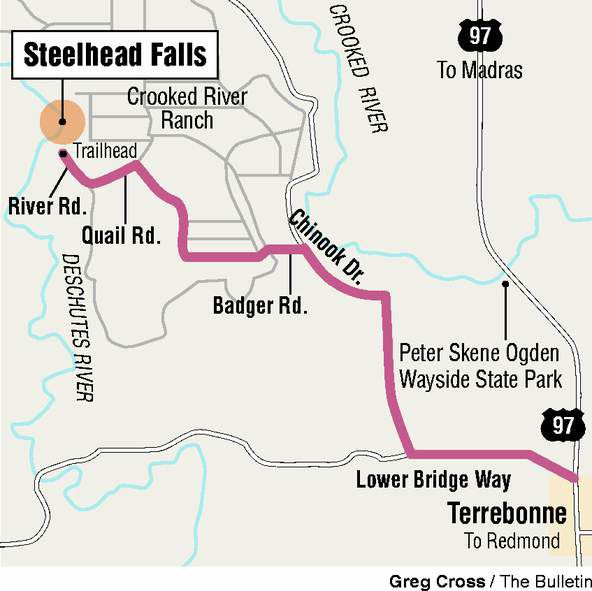
Getting there: From Terrebonne, turn West on Northwest Lower Bridge Way. Proceed a little more than 2 miles, then turn right on Northwest 43rd Street. Take that about 1.8 miles to Chinook Drive. From Chinook Drive, proceed just less than a mile and then turn left onto Badger Road. In a little more than a mile, turn right on Sage Hen Road. After about a half a mile, turn left on Ermine Road. Soon afterward turn left on Quail Road. Take Quail less than half a mile to River Road and turn right. Proceed on River Road downhill to the Steelhead Falls Trailhead.
Cost: Free
Difficulty: Easy
Contact: 541-416-6700
More Local News


Best of the Best of Bend 2025

-
-
-