Why does it feel like spring?
Published 4:00 am Tuesday, December 2, 2008
- Why does it feel like spring?
It’s not looking much like December outside.
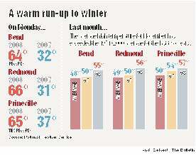
With temperatures in the high 50s to mid-60s in recent days, Central Oregon has been in the midst of an uncharacteristically warm early winter. According to the National Weather Service office in Pendleton, November average high temperatures were 4 to 7 degrees above the long-term trend, which tracks temperatures between 1971 and 2000.
Compared with recent years, the difference is even more substantial. Weather stations in Bend, Powell Butte and Madras showed Monday’s high temperatures between 22 and 30 degrees warmer than recorded on Dec. 1 in any of the last three years.
The warm weather and lack of moisture has been bad news for local skiers and snowboarders. Since 2003, Mt. Bachelor has been able to open the lifts in time for the Thanksgiving holiday every year. In 2006, the ski area boasted a base snowpack of 49 inches the Sunday after Thanksgiving.
But as of Monday, Mt. Bachelor reported just 4 inches of snow at the base and at mid-mountain.
Jon Mittelstadt, a science officer with the Weather Service, said there’s a good chance that more typical winter weather patterns will return to the area by the middle of next week.
This year has been different, he said, due to a large high-pressure ridge currently sitting just off the Oregon Coast. Weather patterns that might otherwise have reached the area have been directed elsewhere, resulting in an unusually warm several weeks.
“The weather patterns, even though there’s day-to-day changes, they will get into block patterns that can persist for two or three weeks, and sometimes longer,” Mittelstadt said. “The energy travels at mid-latitudes from west to east, so most of our weather’s coming off the Pacific Ocean, either from the northwest or the southwest.
“Any systems that do get through are having to come across this high-pressure ridge, so they’re not very strong; they don’t have a lot of moisture. That’s been the situation for most of November, and it led to kind of mild conditions.”
Along with the mild weather, recent weeks have been characterized by the temperature inversions often seen in Central Oregon this time of year, Mittelstadt said. An inversion occurs when warmer air settles in over an area of cooler air, preventing the cooler air from moving out. The result, Mittelstadt said, is frequent occurrences of higher temperatures at higher elevations, such as warmer weather in Bend than Madras, the reverse of what’s typically seen in the summer.
Mittelstadt said the warm start to the winter doesn’t necessarily indicate what’s coming this way in the weeks and months ahead. Summer river levels and irrigation are dependent on winter snowpack, but a dry November doesn’t point toward light snowfall throughout the winter.
“In my 10 years here, November can go either way,” Mittelstadt said. “Of course it’s always nice to get that snowpack started, but it really is those later months that are more important. If they turn out to be cool with plenty of snow, that really sets us up well for the next summer season.”
Although significant snow in the mountains or at lower elevations is still a week or more away, the National Weather Service is forecasting cooler temperatures, with highs dropping down to the mid- to upper 40s for the rest of the week in most of Central Oregon.
More Local News


Best of the Best of Bend 2025

-
-
-