Bend’s Urban Growth Boundary
Published 12:00 am Saturday, April 21, 2018
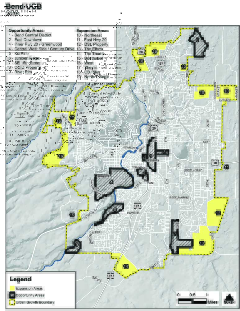
- Map courtesy of the City of Bend
The perennially quotable Mark Twain once quipped, “Buy land, they’re not making it anymore.” If you’re a growing Oregon city bursting at the seams, this statement rings especially true. But rather than buy land, growing cities in Oregon must complete a rigorous process to request additional acres for the expansion of their city limits as defined by an “urban growth boundary.”
Few issues have the ability to impact the future of an Oregon city as significantly as its urban growth boundary (UGB). Enshrined in state land use law following the passage of Senate Bill 100 nearly 50 years ago, the UGB process tasks cities with mapping out their future growth to identify areas for expansion and redevelopment. Housing, employment, infrastructure and transportation are all driven by the UGB process and must be carefully planned so as to comply with state requirements.
Trending
Bend’s plan to expand by 2,380 acres was approved by the state in December 2016, and the city is now tasked with implementing the remand to move its west, north, south, northeast and southeast borders.
Bend’s UGB remand identifies 19 areas of focus, divided almost equally between “opportunity areas” and “expansion areas.” Naturally, some areas are more prime for development and redevelopment than others, due to existing infrastructure and other key factors. But the process must begin somewhere, and so the multi-million dollar question the City of Bend must now answer is “Where?”
At the time of writing, there are a few options that appear to have risen to the surface as potential candidates to get the ball rolling on the UGB. Most notably, areas on the far north, northeast, southeast, and central core have emerged as frontrunners for the plan’s initial implementation. However, land in the north and northeast will be challenging and costly to develop due to a current lack of infrastructure.
In a March 21 meeting, city staff and consultants recommended to city councilors that the plan be rolled out in the Bend Central District (BCD) and southeast “elbow.” According to city staff, the elbow could bring more than 2,200 jobs and upward of 800 homes into the city in 10 years. In addition, the recent completion of the city’s Southeast Interceptor sewer line means that most of the area is ready to be serviced by city sewers.
According to city staff and consultants, the BCD is the prime location for development. Having existing roads, as well as sewer and water infrastructure in the city’s core, means that work in the area would be focused primarily on road improvements. While each option for initial implementation represents tens of millions of dollars in development and construction costs, the Central District’s estimated $27 million price tag is considerably less than the $70 million needed for the southeast elbow and the roughly $50 to $70 million required for expansion in the north.
A tool that could be used to kick-start redevelopment in the BCD is urban renewal, a designation that is currently held by only two areas in Bend: Juniper Ridge and Murphy Crossing.
Trending
The decision of where to begin is critical, as time is of the essence. Bend’s population numbers continue to climb, and estimates from Portland State University indicate that this trend is not likely to change in the near future. Housing options and other services are needed to accommodate such growth. In the midst of an affordable housing crisis, this need is magnified.
Bend may not be able to make more land, but the plans it makes to utilize the acreage available and respond to growth will make all the difference.
Marketplace

Best of the Best of Bend 2025

-
eEdition

-

-