Central Oregon outdoors and trail conditions
Published 6:30 pm Thursday, July 13, 2023
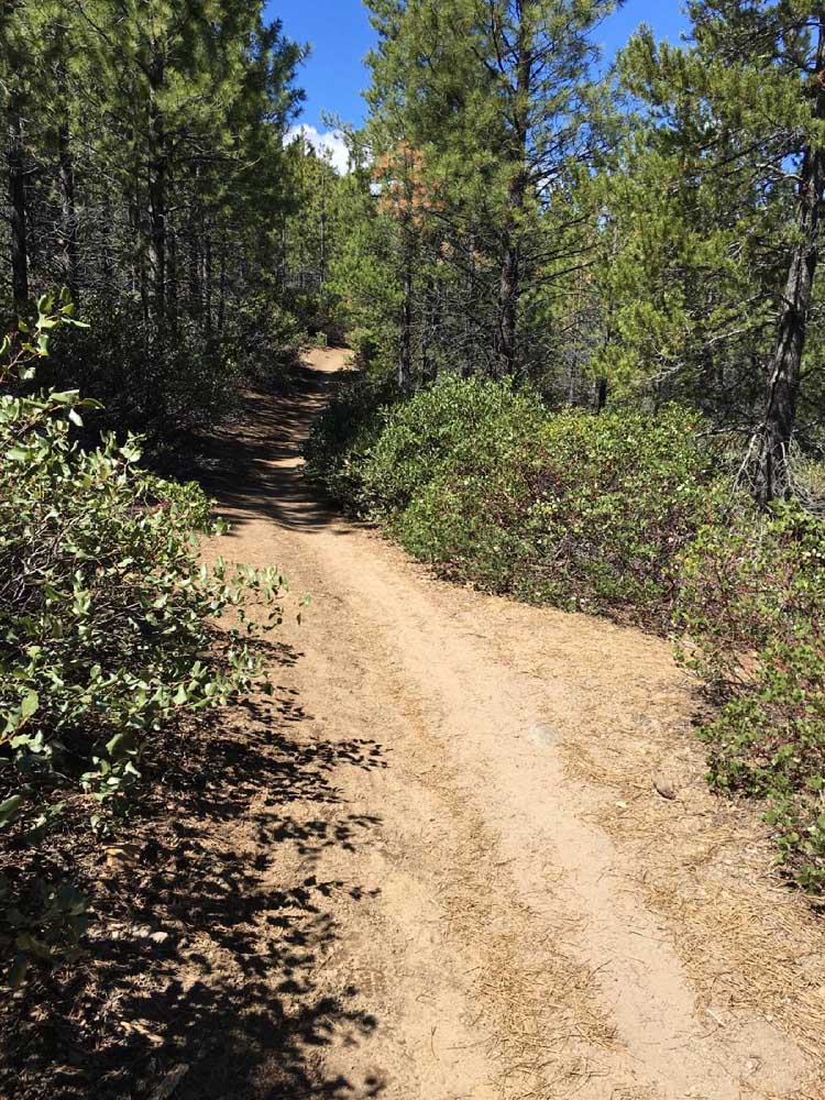
- Pines and manzanita line Tumalo Creek Trail between Skyliner Sno-park and Tumalo Falls.
With the thermostat reaching into the 90s this weekend, one would be wise to keep cool by taking a dip in your favorite lake or splashing around in your favorite river spot.
If you’re heading west into the Cascades, anecdotally speaking, mosquito season has not quite ended: Skeeters were out in droves last weekend at Lucky Lake, but fortunately they can’t swim very well and their numbers typically abate later in the month of July.
Remember to check the forecast, wear sunscreen, bring along plenty of potable water and don’t go it alone, whether you’re heading into the back country or just to the Deschutes River. And if you’re hoping to hike, ride or swim in slightly cooler conditions, the high will be in the low 80s come Monday.
For a full list of conditions updated regularly, please visit centraloregonexplore.com
Hiking and Day Use Sites
NOTE: Trails above 7,000 feet are under snow. See forest websites for more details and restrictions.
Deschutes National Forest
- Aspen Day Use: Open
- Beach Day Use: Open
- Bear Valley Trailhead: Open
- Benham East Trailhead: Open
- Benham West Trailhead: Open
- Bessie Butte Trail: Open
- Besson Day Use: Open
- Big Eddy Day Use: Open
- Big River Boating Site: Open
- Big Obsidian Flow Trailhead: Open
- Black Butte Trailhead: Open
- Black Crater Trailhead: Open; deep snow
- Boyd Cave Day Use Area: Open
- Broken Top Trailhead: Open; deep snow; Central Cascades Wilderness Permit required; Forest Road 370 is closed
- Buttes Loop Trailhead: Open; patchy snow
- Cabot Lake Trailhead: Open; snow free and clear till half a mile from lake
- Cascade Lakes Welcome Station: Closed
- Canyon Creek Meadows: Open; Central Cascades Wilderness Permit required
- Charlton Lake Trailhead: Open; snow
- Chush Falls: Open; snow free and clear
- Cinder Beach Day Use: Open; snow free; operated by the Suttle Lodge
- Cinder Hill Day Use: Open; snow
- Coral Swamp Trailhead: Open; snow; light deadfall
- Crane Prairie Picnic Area: Open; snow
- Crater Ditch Trailhead: Open; Central Cascades Wilderness Permit required; Forest Road 370 is closed
- Crater Rim Trailhead: Open; deep snow
- Crescent Lake Guard Station: Open; snow
- Cultus Lake Day Use Area: Open; deep snow
- Cultus Lake and Winopee trails: Open; deep snow
- Deer Lake Trailhead: Open; snow
- Devil’s Lake/South Sister Trailhead: Open; deep snow; Central Cascades Wilderness Permit required
- Dillon Day Use: Open
- Dutchman Trailhead: Open; snow
- Edison Trailhead: Open; snow
- Elk Lake Day Use: Open; deep snow
- Elk Lake Trailhead: Open; deep snow
- Fall River Trail: Open
- Green Lakes Trailhead: Open; deep snow; Central Cascades Wilderness Permit required
- Green Ridge Lookout: Open
- Green Ridge Trail: Open
- Head of Jack Creek Trailhead: Open; light downfall
- Metolius River Trail: Open
- Horse Butte Trailhead: Open; light deadfall above Swamp Wells Horse Camp near junction with Crater Rim
- Hoffman Island Trailhead: Open; likely snow free
- Irish and Taylor Lakes Trailhead: Open; deep snow
- Jack Lake Trailhead: Open; deep snow; Central Cascades Wilderness Permit required
- Jefferson Lake: Open; snow free first five miles with light downfall
- Lake Creek Trail: Open; snow free and clear
- Lava Butte Interpretation Viewpoint: Open
- Lava Camp Lake Trailhead: Open; deep snow; Central Cascades Wilderness Permit required
- Lava Cast Forest Trailhead: Open; snow free and clear; NW Forest Pass required
- Lava Island Day Use: Open; patchy snow
- Lava Lake Day Use: Open; patchy snow
- Lava Lands: Open; visitor center open with limited hours, trails open; needles may exist on surface; heavy use on weekends
- Lava River Cave — Show Cave: Open; limited capacity, requires timed reservation tickets
- Little Crater Day Use: Open
- Little Fawn Day Use: Open
- Lower Black Butte Trailhead: Open
- Lower Bridge Day Use: Open
- Lower Canyon Creek (West Metolius Trailhead): Open
- Lucky Lake Trailhead: Open
- Meadow Picnic: Open
- Meek Lake Trail: Open
- Meissner Trailhead: Open
- Metolius-Windigo: Open
- Mile Camp Day Use: Open
- Millican Crater Trailhead: Open
- Mirror Lakes: Open
- Moraine Lake: Open
- North Twin Boating Area: Open
- Osprey Point Day Use: Open; possible snow
- Park Meadow: Open
- Paulina Falls Picnic and Trailhead: Open; snow
- Paulina Lake Day Use: Open
- Paulina Lake Loop Trail: Open
- Paulina Peak Trail: Open; Open
- Paulina Visitor Center: Closed
- Peter Skene Ogden Trailhead: Open; snow free on lower portion, deep snow higher up
- Phil’s Trailhead: Open; trail closures include Voodoo Trail from the northern junction with Ben’s south to the junction with Phil’s Trail; Ben’s Trail from the junction with Forest Road 4610 to the junction with FR 4601-300 and Pine Drops/Whoops; Storm King open between Phil’s Trail and FR 4615 but remains closed between FR 4615 south to the junction with COD
- Pine Mountain: Open
- Pole Creek Trailhead: Open; very heavy downfall between a quarter mile from TH and junction with Green Lakes Trail
- Quinn River Boating site: Open
- Rimrock Trailhead: Open
- Rockpile Lake: Open; snow free and clear on lower two miles
- Rosary Lakes Trailhead: Open
- Round Lake Trailhead: Open; light downfall and patchy snow near lake
- Scott Pass Trailhead: Open
- Scout Lake Day Use: Open
- Simax North and South Beach area: Open
- Sisters Cow Camp: Open
- Sisters Mirror Trailhead: Open; possible snow; Central Cascades Wilderness Permit required
- Summit Lake: Open; possible snow
- Sun Lava Trailhead: Open; snow free and clear; heavy use on weekends
- Suttle Lake Day Use: Open; snow free and clear
- Swampy Lakes Trail: Open; possible snow
- Tam McArthur Rim Trailhead: Open; snow; Tam Rim Horse trail has light deadfall; Central Cascades Wilderness Permit required
- Ten Mile Trailhead: Open
- Tenino Boating Site: Open
- Tandy Bay Picnic Area: Open
- Todd Lake Trailhead: Open; snow; do not trample restoration areas; Central Cascades Wilderness Permit required for the Todd Lake Trail, lake access is open without permit
- Tranquil Cove Day Use: Open
- Tumalo Falls Trailhead: Open; Road to Tumalo Falls open for the season; blowdown on Swampy Lakes Trail and upper portions of Bridge Creek
- Tumalo Mountain: Open; clear
- Wake Butte Trailhead: Open
- Wanoga Trailhead: Open
- Whychus Creek Overlook Trailhead: Open; snow free and clear
- Whychus Portal (Lower Whychus Trailhead): Open; snow free and clear
- Wickiup Plains Trailhead: Open
- Winopee Trailhead: Open; possible snow; likely moderate downfall
- Wyeth Boating Site: Open
Ochoco National Forest
- Alder Springs Trailhead: Open
- Antelope Flat Reservoir: Open
- Hammer Creek Trailhead: Open
- Rock Creek Trailhead: Open
- Walton Lake Trailhead: Closed
Bureau of Land Management
- Lower Crooked River: Open
- North Fork: Open
- Scout Camp Trail: Open
- Steelhead Falls Trail: Open
- Trout Creek Trail: South side of trail, including Trout Creek climbing walls is closed through Aug. 31
Oregon State Parks
- Cline Falls State Scenic Viewpoint: Open
- Cove Palisades State Park: Open; all campgrounds, cabins and moorage slips are open
- Jasper Point: Open; campfires, charcoal fires, propane fire rings and tiki torches are prohibited in outlying recreation spots that include North Road, County boat ramp, Bear Creek and Robert’s Bay. Propane stoves allowed for cooking only. Campfires are allowed in the Prineville Reservoir and Jasper Point campgrounds only.
- La Pine State Park: Open
- Prineville Reservoir State Park: Open; campfires, charcoal fires, propane fire rings and tiki torches are prohibited in outlying recreation spots that include North Road, County boat ramp, Bear Creek and Robert’s Bay. Propane stoves allowed for cooking only. Campfires are allowed in the Prineville Reservoir and Jasper Point campgrounds only.
- Smith Rock State Park: Open; climbing closures to protect nesting raptors in place until August; park-wide drone ban is in effect.
- Tumalo State Park: Open
Camping
Deschutes National Forest
- Allen Springs Campground: Open
- Allingham Campground: Open
- Big Cove Boat-in Campground: Open; no fires
- Big River Campground: Open
- Blue Bay Campground: Open
- Bull Bend Campground: Open; no fires
- Camp Sherman Campground: Open
- Candle Creek Campground: Open
- Cold Springs Campground: Open
- Contorta Flat Campground: Open
- Contorta Point Group Campground: Open
- Crane Prairie Campground: Open
- Crescent Creek Campground: Open; no fires
- Crescent Lake Campground: Open
- Cultus Corral Horse Camp: Open; no fires
- Cultus Lake Campground: Open
- East Davis Lake Campground: Open
- East Lake Campground: Open
- Elk Lake Campground: Open
- Fall River Campground: Open
- Fall River Guard Station: Open
- Gorge Campground: Open
- Indian Ford Campground: Open
- Jack Creek Campground: Open
- Lava Lake Campground: Open
- Link Creek Campground: Open
- Little Cove Boat-In Campground: Open; no campfires
- Little Crater Campground: Open
- Little Cultus Campground: Open
- Little Fawn Campground: Open
- Little Lava Lake: Open
- Lower Bridge Campground: Open
- Lower Canyon Creek Campground: Open
- Mallard Marsh Campground: Open
- McKay Crossing Campground: Open; no campfires
- Monty Campground: Open; no fires
- North Twin Lake Campground: Open
- Paulina Lake Campground: Open
- Perry South Campground: Open
- Pine Rest Campground: Open
- Pioneer Ford Campground: Open
- Point Campground: Open
- Prairie Campground: Open
- Princess Creek Campground: Open
- Pringle Falls Campground: Open; no campfires
- Riverside Campground: Open
- Rock Creek Campground: Open
- Scout Lake Campground: Open
- Simax Group Campground: Open
- Smiling River Campground: Open
- Soda Creek Campground: Open; no campfires
- South Campground: Open
- South Shore Campground: Open; no campfires
- South Twin Lake Campground: Open
- Spring Campground: Open
- Sunset Cove Campground: Open
- Trapper Creek Campground: Open
- West South Twin Campground: Open
- Windy Group Campground: Open
- Wyeth Campground: Open; no campfires
Ochoco National Forest
- Antelope Flat Reservoir Campground and Day Use: Open
- Big Spring Campground: Open; no campfires
- Biggs Springs Campground: Open; no campfires
- Bingham Springs Campground: Open; no campfires
- Cottonwood Campground: Open; no campfires
- Cottonwood Pit Campground: Open; no campfires
- Sugar Creek Campground and Day Use Area: Open
- Walton Lake Campground: Open
- Walton Lake Group Campsites: Open
BLM — Prineville District
- Big Bend Campground: Open; no campfires
- Castle Rock Campground: Open
- Chimney Rock Campground: Open
- Cobble Rock Campground: Open
- Lone Pine Campground: Open
- Palisades Campground: Open
- Post Pile Campground: Open
- Steelhead Falls: Open; no potable water; no campfires
- Stillwater Campground: Open
Cycling
Wanoga Trail Complex
- Voodoo Trail will be closed from the northern junction with Ben’s south to the junction with Voodoo Child Trail Monday-Friday
- Phil’s Trail from FR 300 near EXT Trail to FR 4610 closed Monday-Friday
- Kent’s Trail between junction with Phil’s Trail and KGB Trail closed Monday-Friday
- Tiddlywinks: Sandy/loose
- All other trails riding well
North of Skyliner trails
- All trails riding: Riding well
Swampy Lakes trails
- Upper Flagline, Middle Flagline, Met-Win, Flagline Tie, Flagline Access: snow
- All other trails riding well
Mt. Bachelor
- Bachy West XC: Deep snow
- Blade Runner, FTL, Lava Flow Lower: Riding well
- All other trails closed
Sunriver area trails
- All trails riding well
La Pine
- Crater Rim: Snow
- La Pine State Park: Riding well
Sisters trails
- Green Ridge: Sandy/loose
- Metolius Windigo (99 Upper): Deep snow
- Upper Butte Loop: Variable
- All other trails riding well
Cascade Crest
- Chimney Peak, Crescent Mountain North, Gordan Peak, Scar Mountain: Variable
- Cone Peak, Crescent Mountain South, Iron Mountain, North Pyramid, Pyramid, South Pyramid Creek: Riding well
- Other trails possibly under snow
Fire danger is listed as Low in the Ochoco National Forests and the Crooked River Grasslands, the Deschutes and the Willamette National Forests.
Industrial Fire Precaution Level has been lowered to 1 as of April. 1 in the Deschutes, Ochoco and the Crooked River Grasslands and the Willamette National Forests.
As of July 22, 2020, Deschutes River access is closed due to safety concerns and to prevent further erosion to the riverbank. The access point will be closed until further notice. For more information visit bendparksandrec.org
• The Monument Area will be closed to climbing beginning Jan. 18, 2022.
• The Canyon Trail near the Bald Eagle nest is restricted to travel in groups of four or fewer, and noise needs to be kept to a minimum.
• Peregrine and Prairie Falcon climbing closures will go into effect at a later date.
• A park-wide ban on drones is in effect for remainder of nesting season.


Best of the Best of Bend 2025

-
-
-