Where Central Oregon mountain bikers can go to avoid sand
Published 6:00 am Friday, August 11, 2023
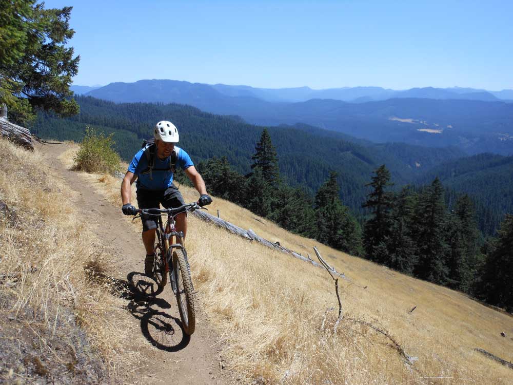
- A mountain biker cruises along the Alpine Trail above Oakridge.
When traveling to the Oregon Coast, I don’t usually bring along my mountain bike.
But ahead of our family vacation to Port Orford on the southern coast, I heard about a relatively new trail system between Bandon and Coos Bay, not far from our Vrbo.
According to traveloregon.com, the Whiskey Run trail system is billed as the best mountain biking on the Oregon Coast, and after nearly four hours on the fast, flowy, clay-dirt trails, it is hard to argue with that assessment.
Whiskey Run
Whiskey Run features a tight network of 37 miles of trails and more than 7,000 feet of descent amid a thick coastal forest canopy. The trails were firm and smooth and not sandy or dusty at all, offering a break from such conditions this time of year on our Central Oregon trails.
Whiskey Run opened in 2018 and now includes 24 green (beginner) trails, 18 blue (intermediate) trails and 14 black or double-black (advanced) trails. The system is incredibly well-signed, and I never felt lost during my first time in the area.
Some of the more advanced trails feature technical jumps and berms, but I found the green trails such as Dirty Dishes and Hollerback to be the most fun. The trails took me on a loop that featured sidehill riding and banked turns through a lush forest of ferns and tall timber. At one point the canopy made it so dark it felt like nighttime in the middle of a clear, sunny day.
According to mtbproject.com, the Whiskey Run Trails were envisioned and built through a partnership among Wild Rivers Coast Alliance, Coos County Commissioners and County Foresters, Travel Oregon and others.
“The trails are a blend between flow and cross-country style, and are great for all levels of riders with open sight lines, easy climbs, and chances to catch some air if you want,” notes mtbproject.com.
I rode more than 18 miles in 3 hours, 40 minutes, sampling as much as I could of the coastal flow trails that provided a respite from the sandy trails of Bend.
If you’re looking to escape the sand and dust of August in Central Oregon, here are a couple of more options for mountain biking that are closer to Central Oregon:
Alpine Trail in Oakridge
The Alpine Trail is the crown jewel of the 300 miles of singletrack in the Oakridge area, about a two-hour drive southwest from Bend and a 45-minute drive southeast from Eugene.
The trails near Oakridge — many of them difficult to find — are tucked into the sometimes rolling, sometimes steep hills of the western slope of the Cascade Range.
Unlike Central Oregon, where the gently rolling east slope of the Cascades offers gradual climbs that lend the area to more loop rides, the Oakridge area often requires shuttles.
Elkhorn Mountains in northeast Oregon offer hiking, mountain biking adventures
Also unlike Central Oregon, the Oakridge trails do not become particularly dusty during the summer, instead staying relatively tacky and firm.
The Alpine Trail cuts through enormous old-growth Douglas fir trees that highlight the Willamette National Forest. After Windy Pass, the Alpine Trail is about 7 miles of continuous downhill into the small community of Westfir.
The trail is about 15 miles through grassy meadows and deep forest as riders descend about 3,500 feet.
But although it is the crown jewel, Alpine is just one 15-mile strip of dirt in an area that holds hundreds more miles of hidden trail treasure for mountain bikers.
McKenzie River Trail
The 26½-mile McKenzie River National Recreation Trail can certainly be completed in one day by a motivated mountain biker. But in my experience, the ride is much more enjoyable when the technically demanding upper portion is skipped.
The McKenzie River Trail (MRT), which straddles the border of Lane and Linn counties on the western flank of the Cascade Range, is known for the clear, rushing water of the river, spectacular waterfalls and towering old-growth Douglas fir trees.
It starts out easy around the west side of Clear Lake and becomes extremely technical over the rugged lava rock near the Sahalie and Koosah waterfalls all the way to Trail Bridge Reservoir. From the reservoir, the trail becomes a smooth path of flowing singletrack down to the McKenzie Bridge Ranger Station at its south end.
The trail is pretty much halfway between Bend and Eugene along state Highway 126.
A shuttled ride from Trail Bridge Reservoir, the midpoint of the trail, down to the ranger station, avoids the difficult lava rock section. An out-and-back ride from near the south end of the trail at Paradise Campground is also an option.
One constant along the trail — and what makes it so different from any trail in Central Oregon — is the lush greenery of the Willamette National Forest. Bright green ferns, moss-covered Douglas firs and endless deciduous trees line the trail. The forest is so thick in spots that heavy shade is almost constant and the path is rarely sandy or dusty.
The entire north-to-south ride along the MRT includes an elevation loss of 1,600 feet.


Best of the Best of Bend 2025

-
-
-