Tam McArthur Rim hike: A relatively easy trek with rugged Cascade views
Published 12:00 pm Friday, August 23, 2024
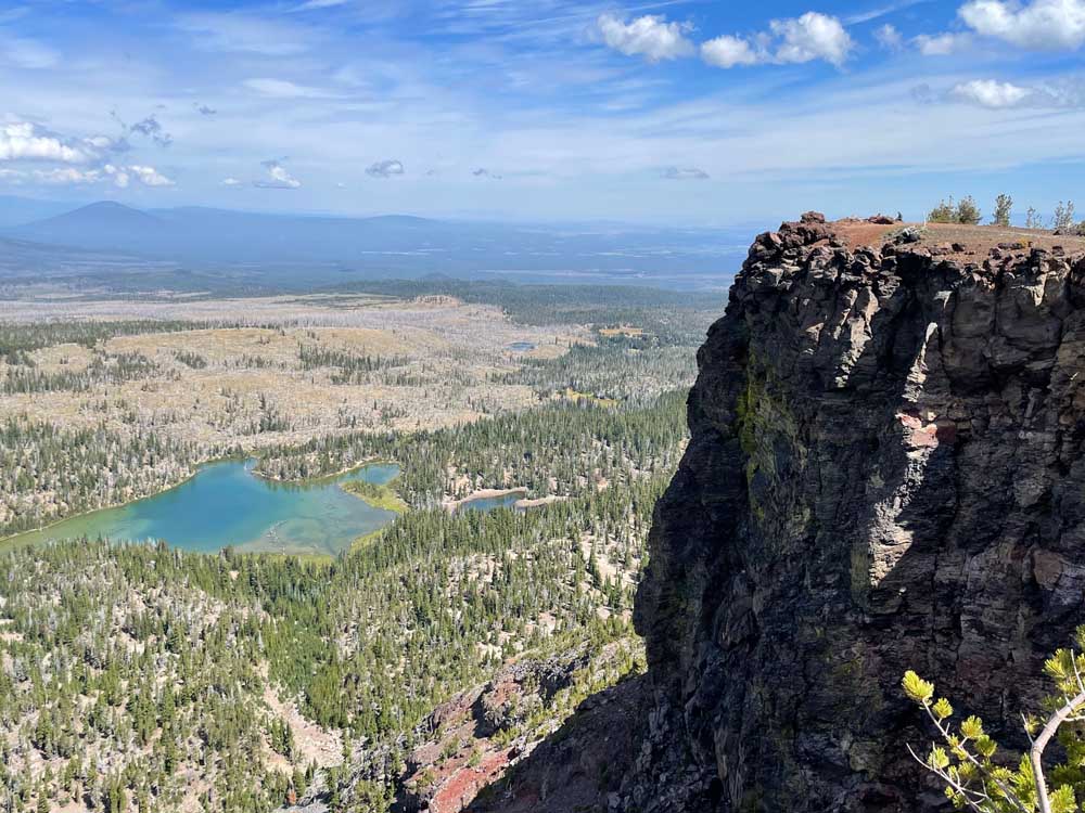
- Little Three Creek Lake as seen from Tam McArthur Rim.
Tam McArthur Rim is a wintertime haven for backcountry skiers and snowboarders in Central Oregon. The area features a vast array of perfectly pitched north-facing slopes, and Three Sisters Backcountry Inc. offers guided ski trips and camping in yurts on the shore of Three Creek Lake just below the rim.
In the summertime, those slopes are mostly bare, but the area still provides ample opportunities for outdoor adventure. Fishing and paddling are popular activities on pristine Three Creek Lake.
For hikers, a 2½-mile-long trail leads from the lake to the top of Tam Rim, offering sprawling views of Cascades peaks to the west and the vast High Desert to the east.
The 5.3-mile round-trip hike to the rim from the trailhead at Three Creek Lake includes 1,400 feet of elevation gain — the high viewpoint sits at 7,730 feet — and typically takes no more than three hours. The relatively easy trek is nontechnical and good for kids, but does require Central Cascades Wilderness permits through Oct. 15. Permits are available for $1 on recreation.gov either 10 days or two days before the trip.
The drive from Bend to the Tam McArthur Rim Trailhead requires about an hour. Part of the road into Three Creek Lake is gravel and a bit bumpy, but the hike is well worth the drive.
I secured my permit 10 days in advance and made the drive to Three Creek Lake on Monday morning. Several anglers and paddlers were enjoying the serenity of the small alpine lake.
A few other hikers were starting out as well, but I ended up having the trail to myself during most of the ascent to the rim.
The trail began just across the road from Three Creek Lake and led me up dusty switchbacks to the opposite side of the rim. Views of the lake and North and Middle Sister popped up to the west as I climbed.
Eventually, the trail flattened as I reached the crest of the rim along an open plateau. The section was hot and treeless, and luckily I had lathered the sunscreen on before starting the hike.
The final short, steep push to the viewpoint is the most challenging section of the trek. From the top of the ridge, pointy, jagged Broken Top dominated the horizon to the west. The trail cut along the edge of the rim, and I could see both Three Creek Lake and neighboring Little Three Creek Lake far below.
The summit of the rim offers a rocky, flat area from which to view numerous Cascade peaks. Mount Washington, Three Fingered Jack and Mount Jefferson were all visible to the north on the partly cloudy, smoke-free day. North Sister and Middle Sister jutted skyward to the west.
According to the Oregon Historical Society, the rim is named for Lewis A. McArthur, known as “Tam” McArthur, who was an executive for Pacific Power & Light Company and also secretary for the Oregon Geographic Board for many years. In 1928, McArthur published his book “Oregon Geographic Names,” which is now in its seventh edition and is a comprehensive source on the origins of Oregon place names.
The trail officially ends at the viewpoint, but an unmaintained trail continues west along the rim and eventually connects to other trails near Broken Top. Motivated hikers can follow the trail all the way to No Name Lake at the base of Broken Top, which makes for an 11½-mile roundtrip outing with about 2,200 feet of elevation gain from the Tam Rim Trailhead.
I followed the trail for about a half mile or so but eventually turned around and made my way back down toward Three Creek Lake. By the time I made it back to the trailhead, I had completed 6.1 miles in about three hours.
A refreshing dip into Three Creek Lake was the perfect way to cap a memorable hike in the Central Oregon Cascades.


Best of the Best of Bend 2025

-
eEdition

-

-
Go! eEdition