Snow makes summiting difficult at Black Crater near Sisters
Published 10:00 am Thursday, July 10, 2025
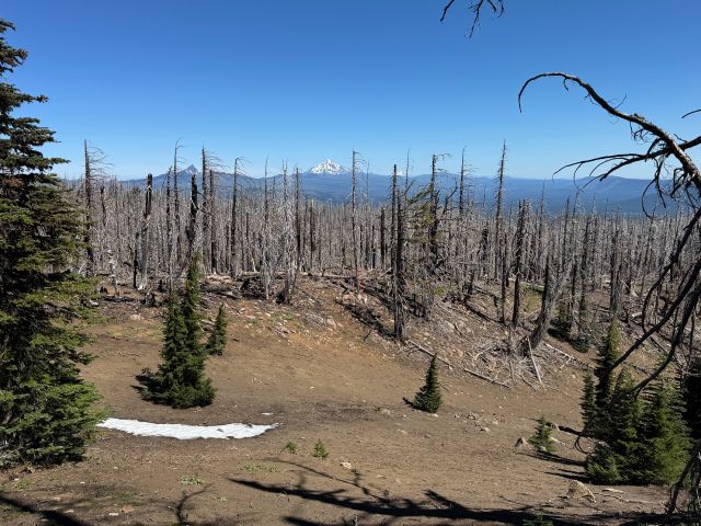
- Glacier-carved meadows are some of the defining features of Black Crater, 11 miles west of Sisters. Dead trees, sans needles, offer a less obstructed view of cascade peaks, including, from left to right, Washington, Jefferson and Hood. (Jeremy Dickman)
I get that lingering cascade glaciers are a good omen for our mountain streams, but that doesn’t make “glacier rash” hurt any less.
What’s “glacier rash,” you ask? That sounds like a question from someone who hasn’t slid down a snowfield in hiking shorts while searching for a still-buried trail. Antiseptic ointment costs aside, an early July hike up Black Crater is well worth most of the scars you are likely to bring home.
No walk in the park
Nestled between North Sister and Mount Washington about a 10-mile drive directly west of Sisters, Black Crater is one of the lesser-known features of our Western skyline in Central Oregon. A shield volcano that has been dormant for some 50,000 years, Black Crater was most recently the site of the Milli fire in 2017, and eight years hence, blackened tree skeletons are peppered with purple and red and pink wildflowers along the crater’s northeastern flank.
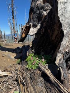
Pink wildflowers find a home in the carcass of a tree that burned in the 2017 Milli fire. (Jeremy Dickman)
Trending
At 7.2 miles and around 2,200 feet of elevation gain, the Black Crater Trail is not a mere walk in the park. Its first two miles are, thanks to the fire, very exposed and not conducive to hot temps. Our cool, 55-degree Saturday morning was the perfect launch conditions for my 13-year-old son and I to attack the summit. We had frequented the Black Crater Trail before, most recently during the dog days of the second (or third?) wave of the COVID-19 pandemic in August 2021. That trip was snow-free, and our tired legs were rewarded with a summit party near the site of an old U.S. Forest Service fire lookout post.
It turns out, a high-Cascade trail can look starkly different between July and August. At approximately mile 2.2 of our uphill slog, a football field’s worth of snow greeted us at a turn in the trail. It was a welcome respite for our 2-year-old black lab. Tail wagging, tongue hanging, Tilly slobbered her way through a euphoric circuit of mile-high zoomies. My son was all too willing to throw sticks and encourage this barbaric behavior to the shock and dismay of some senior citizens who passed us by. Leash laws may or may not have been flouted, but I believe summertime snow is an affirmative defense to such violations in court.
The midway glacier served as a warning, but we did not heed it. Roughly one-third of a mile from the summit, we ran into another snowfield. This one was strategically placed on a steep incline to thwart even the most intrepid invaders. Had we crampons and ski poles, we likely would have had our second summit party in less than 4 years. Alas, my son’s Nikes and the featureless tread of my Merrill hiking shoes were not up to the task.
It wasn’t for lack of trying. July snow is well packed, and post-holing for traction simply wasn’t an option. Instead, we side-hilled for 50 feet or so, and the aforementioned glacier-slide resulted in me leaving a few layers of skin on the volcano’s flank. I tipped my cap, surrendered, and my son and I agreed that 6.5 miles and 1,900 feet of climbing was respectable enough for one morning.
Results and views may vary
To those with the equipment and chutzpah to make it to the summit that day, you were greeted by a cobalt-blue sky, and views of every peak from Mount Hood to Broken Top. Online trail reviews appear to report that the craggy, cinder-coated summit itself is snow-free. Bummer for us.
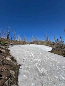
Early July is still snow season if you go high enough in Central Oregon. At 6,000 feet, roughly 2 miles from the Black Crater trailhead, this monster snowfield served as a playground for my 2-year-old black lab and his teenage human brother. (Jeremy Dickman)
The Black Crater Trail is a gorgeous enough route even without summit views. Steeply emerging from the parking lot just off Oregon Route 242, the sandy trail climbs and then dips into enormous meadows where past glaciers have dug out craters. Penstemon, lupine, and abundant bitterroot line the trail, sprinkling the dead tree roots with color. Tiny spruce saplings have taken hold in the hillside’s recovery efforts, nearly a decade after a fire wiped out most of the green. Chipmunks and brilliantly covered moths and butterflies dance in the sunshine.
Trending
Just before the summit, the sub-alpine wildflowers grow more abundant, this time shaded by windswept, whitebark pines. The dusty pumice of the first 3 miles gives way to bright red cinder rock. At the summit, views of the western slopes of the Cascades, every significant peak in Central Oregon, and the tri-city areas of Deschutes County are visible. At four hours, it is one of the hours-per-view-bargain hikes you can find on the High Desert. You’ll be tired by day’s end, but not, say, South Sister tired.
The Black Crater Trailhead is also one of the easiest to find. From Bend, head to Sisters, seek Oregon Route 242 (the same road upon which you can find Sisters Middle School), and drive due west up the McKenzie Pass. The road narrows significantly a few miles outside of town, and it is a popular road route for cyclists, so take the turns slowly.
Unless you have Yak Trax, poles, crampons, or other snow gear, you may also want to wait a few weeks for snow-free trekking to the summit.
Marketplace


Enter the $5,000 Sweepstakes

-
eEdition

-

-