Northwest Travel: Brookings
Published 12:00 am Sunday, April 12, 2015
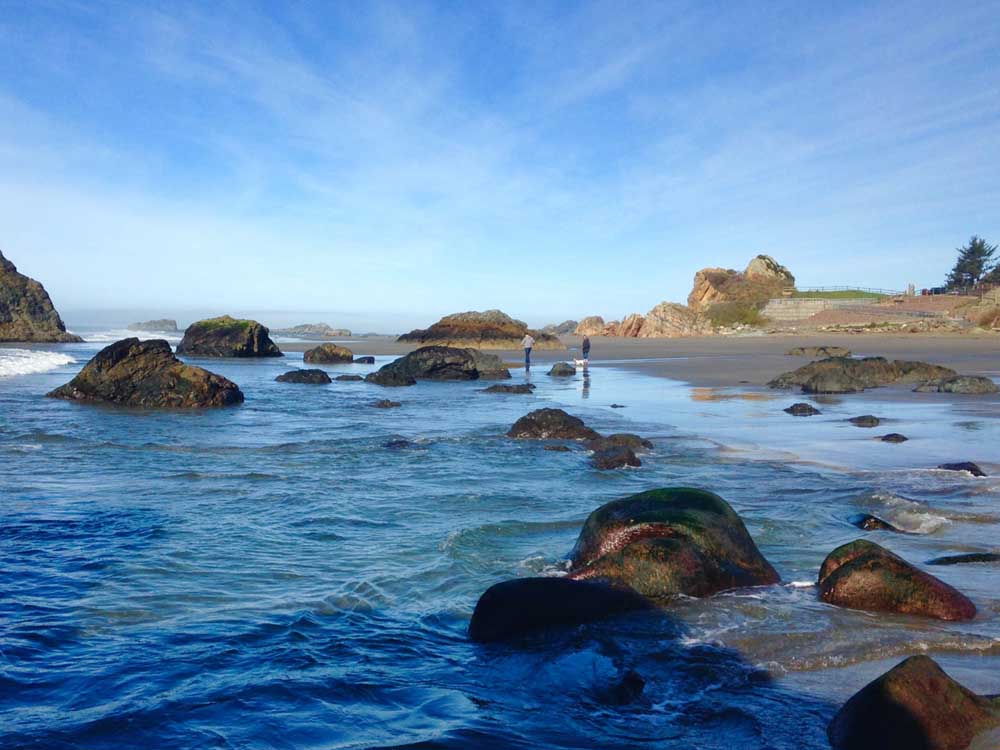
- John Gottberg Anderson / For The BulletinAn ebbing tide swirls around shoreline rocks at sheltered Harris Beach, favored by shell seekers and tide-pool explorers. Just offshore is Goat Island, a 21-acre wildlife refuge that is home to more than 100,000 sea birds of 11 species, including Leachs storm petrel.
BROOKINGS — No town on the Oregon coast is farther from Bend than this Chetco River community of 6,500 in Curry County. It’s so distant from Central Oregon that the quickest route by car (nearly 300 miles) includes a path through California redwoods. Yet Brookings offers plenty of reasons to visit, especially if those reasons are counted in spectacular beach-scapes and dense, old-growth forests. It is, indeed, the only place in the Pacific Northwest where redwoods grow within a few miles of the Pacific Ocean. {%TravBrookings-p15 041215%}
The climate is considered moderate, at least enough to label Brookings as a prime retirement location for throngs of refugees priced out of Southern California. Maybe that’s why some roads offer a chance to reminisce. Detour off Chetco Avenue, as U.S. Highway 101 is known in downtown Brookings, and you might wind up passing time on Easy Street or Memory Lane.
Mild temperatures, ample rainfall and rich soil have made Brookings an ideal location for growing things, whether grasses for livestock, forests for the timber industry or bulbs for the wholesale nursery market. In particular, the area is renowned for its daffodils and Easter lilies.
It’s not a false claim to refer to this area as the “Easter Lily Capital of the World”: More than 75 percent of commercial Easter lily bulbs are produced on the coastal lowland between the Chetco and California’s nearby Smith River. As early as mid-March, lilies are in bloom at Azalea State Park in the heart of Brookings. One yellow pistil rises from deep within the heart of each trumpetlike blossom, whiter than snow. {%TravBrookings-p3 041215%}
The native azaleas themselves embellish the park with thousands of blossoms from April to June. Estimated to be more than two centuries old, they were rescued from an invasion of Himalayan blackberry vines by proud area residents, who also gave the park its picnic area, children’s playground and summer band shell.
Also in Azalea Park is the lovely Capella by the Sea, a chapel built in 2009 by Oscar-winning film editor Elmo Williams, a longtime Brookings resident, in memory of his wife, Lorraine. Three stories tall, built mainly of Douglas fir and topped by seven copper spires, the A-frame-style sanctuary has more than 1,000 square feet of glass across its frame. {%TravBrookings-p4 041215%}
Brookings’ social calendar is built around the annual Azalea Festival, held each year over Memorial Day weekend. Many a local high school girl has dreamed of being crowned festival queen. Four days of events include a parade, a car show, an arts and quilting show, a children’s carnival, a flower show and parties. And what would a coastal festival be without slug races?
A little history
Brookings got its start in 1912 as a company lumber town. John Brookings (cousin to Robert Brookings, who founded the renowned Brookings Institute) was a lumberman in Southern California’s San Bernardino Mountains. After his Brookings Timber & Lumber Co. laid claim to more than 27,000 acres of woodland between the Chetco and Pistol rivers — a stretch of about 17 miles — Brookings decided that his namesake town could be built atop a low bluff, on the north side of the Chetco River mouth.
Although Spanish galleons had sailed past this coast in the 1700s, it wasn’t until 1828 that the native Chetco Indians first met white intruders. The Jedediah Smith party found about 350 Athabaskan-speaking natives in three villages. The tribe supplemented its seafood-dominant diet with acorns, roots and berries foraged from the forests and an occasional deer or elk.
The first land claims were placed in 1853, although the discovery of gold (along with chromite and boron) never played out in large quantities. Settlements were small and scattered until 1891, when the village of Harbor was established on the south bank of the Chetco. That helped to stabilize a small fishing industry, but it did nothing to quell differences between the Coolidges and Van Pelts, settlers who had nothing on the Hatfields and McCoys. A Brookings historian said the only place hotter than the Chetco “was hell with the screen door open,” as the local newspaper wrote.
Brookings’ company town did provide stability. The businessman built a harbor, a railroad and a sawmill and hired San Francisco architect Bernard Maybeck, a proponent of the Arts and Crafts movement, to set the street design. A bridge across the Chetco River, connecting Brookings with Harbor, was built in 1915.
The company didn’t have staying power. It sold within a few years to the California & Oregon (C&O) Lumber Co., which in turn closed its mill in 1925. When the Chetco River bridge collapsed that year, the town was devastated. But it rebuilt on fishing — cod, rockfish, sole and other bottom fish and, of course, salmon — and rekindled its lumber business as a plywood producer during World War II.
The war brought a touch of publicity. The only Japanese bombing of the U.S. mainland took place Sept. 9, 1942, when a seaplane dropped two 168-pound fire bombs in the dense forests east of Brookings. They failed to ignite the hoped-for conflagration, however. Twenty years later, the pilot of that bomber, Nobuo Fujita, returned to Brookings, where he humbly surrendered his 16th-century samurai sword (it now hangs in the Chetco Community Library) and donated money for the purchase of books about Japan.
Quiet town, wild coast
Brookings today is a quiet town, the first stop in Oregon for northbound travelers on U.S. Highway 101 from Crescent City, California. It’s 5 miles north of the border, and the first of several small towns, including Gold Beach and Port Orford, that support most of the sparse population of Curry County.
Area residents know this stretch as the “Wild Rivers Coast.” Embracing the estuaries of the Klamath, Smith, Winchuck, Chetco, Pistol, Rogue, Elk, Sixes and Coquille rivers in two states, this region is cloaked in dense forest and designated wilderness (including the 180,000-acre Kalmiopsis Wilderness) east of its coastal fringe. {%TravBrookings-p7 041215%}
This is the northern edge of the range of the coast redwood. A couple of groves of these forest giants are accessible, by gravel road and forest trail, east of Brookings. Perhaps the most readily visited is just above the Chetco River, 0.8 mile past Alfred A. Loeb State Park, itself best-known for its Oregon myrtle woodlands.
Coast redwoods are among the oldest and tallest living things on the planet. Less than 50 miles south of here are a handful of 2,000-year-old trees. Those in this glen are no slouches — at more than 300 feet tall and 15 feet in diameter, they have been estimated at 300 to 800 years old. {%TravBrookings-p6 041215%}
The Chetco region is proud of its trees. On the grounds of the Chetco Valley Historical Museum, 2½ miles south of Brookings on U.S. 101, stands what is claimed to be the largest Monterey cypress in the United States.
Eighteen feet in diameter and 130 feet tall, it was planted in 1857 by pioneer settler Harrison Blake. Blake’s wood-frame house, the same age as the tree, houses an excellent collection of artifacts.
The place to go in Harbor is, indeed, the harbor — the Port of Brookings-Harbor, to be precise. The chamber of commerce has its visitor center here, near a row of waterfront shops that include a fish-and-chips cafe, a coffee shop and a nautical knickknack dispensary, as well as a sport-fishing charter operator and the requisite seaside bars. {%TravBrookings-p10 041215%}
Nearby, off Boat Basin Road, the Best Western Plus Beachfront Inn overlooks the fishing-boat marina on one side, the crashing surf on the other. There are more restaurants and two RV parks in this area, as well.
Downtown Brookings is just north of the bridge that crosses high above the Chetco River. Here, U.S. 101 is known as Chetco Avenue. Several blocks of businesses, including restaurants, motels and an old-time movie theater are wedged between a couple of modern pubs. I had a comfortable stay in the Wild Rivers Motorlodge.
Up the coast
But the leading attraction in the Brookings area, beyond question, is the Pacific coastline itself. From Harris Beach, at the northern edge of town, through the 12 miles of Samuel H. Boardman State Park, to Cape Sebastian and Gold Beach, giant surf-ravaged sea stacks divide one sandy beach from another. Trails wind down steep bluffs through forests of centuries-old Sitka spruce, lazy hemlocks and aromatic cedars.
Harris Beach State Park rests within the Brookings city limits. The campground here is a fine place to spend a weekend, as it has sites for tents and RVs,and half a dozen yurts. Evening campfire programs and a kids playground entice families. The sheltered beach, enclosed on both sides by lofty rocks, is a great place to scour the sands for shells and colorful rocks, and at low tides for exploring tide pools. {%TravBrookings-p11 041215%}
The park also has several trails from which day hikers can get fine views south, toward central Brookings, and northwesterly in the direction of Goat Island. The largest unit of the Oregon Islands National Wildlife Refuge, created in 1936, the 21-acre island is home to more than 100,000 sea birds of 11 species, many of which dig burrows in which to nest. Especially prevalent is the Leach’s storm petrel, a small, graceful and largely nocturnal bird.
Boardman Park is a designated “state scenic corridor” that begins just north of Harris Beach and continues nearly to Pistol River State Scenic Viewpoint. Apart from various scenic turnouts, it includes Lone Ranch Beach, popular among surfers and kite flyers, in the lee of Cape Ferrelo; Whaleshead Beach, beneath a resort community of the same name; Indian Sands, where archeologists have unearthed native artifacts more than 10,000 years old, and the Thomas Creek Bridge, highest in Oregon at 345 feet. {%TravBrookings-p13 041215%}
Near the northern end of the corridor is a stretch of particularly interesting offshore formations, including the Natural Bridges and Arch Rock. The latter includes a picnic area in a wildflower-rich meadow. Hidden inlets, including Thunder Rock Cove and Hidden Beach, are sheltered by the sea stacks and headlands, such as Deer Point.
Just past the estuary of the Pistol River, Highway 101 rises more than 700 feet to the steep, forested headland of Cape Sebastian. From this windy outpost, the view stretches across 50-plus miles of Pacific coastline, south into California and north to Humbug Mountain, near Port Orford.
For more amazing views, the back road from Brookings to Pistol River delivers. Reaching a high point of 1,715 feet, the Carpenterville Road follows a wooded ridge that affords a bird’s-eye perspective on the landscapes offshore Boardman State Park. If you’re fortunate, you might — as I did — spot deer browsing the grassy openings in the hillside forest below.
— Reporter: janderson@bendbulletin.com
Editor’s note: This article has been corrected. The original version misstated the county seat of Curry County. The county seat is Gold Beach. The Bulletin regrets the error.


Best of the Best of Bend 2025

-
-
-